1970s Maps of Aurora County, South Dakota
Explore 13 historic maps of Aurora County from the 1970s. These maps offer a rare glimpse into what life looked like during the 1970s — showing old roads, neighborhoods, homes, and landmarks that have changed or disappeared over time.
Whether you're researching your family's past, planning a metal detecting trip, or studying how Aurora County's landscape evolved across the 1970s, these high-resolution maps are a powerful tool for exploring the history of this region.
- Focus on a specific era: All maps on this page are from the 1970s, giving you a focused view of this time period.
- See what’s changed: Compare century-old streets, trails, and buildings to today's modern landscape using overlays and satellite layers.
- Research with precision: Use these maps for genealogy, historical research, land use analysis, or educational projects.
- View, download, or print: Maps are fully viewable online in high resolution, and can be downloaded or printed for your own records.
Start exploring Aurora County's history through authentic maps from the 1970s. This is your window into the past.
Aurora County, SD maps
(13)- 1979 Map of Cedar Grove Colony, 1980 Print
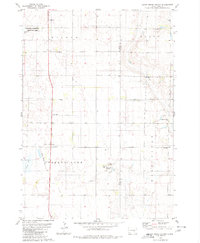 1979 Cedar Grove Colony1980 Print · USGSThe Brule County prairie during the late seventies shows a landscape of established farm colonies and rural parish life. Genealogists can trace family landmarks like Larson Cem and Bulls Cem or local centers like the Cedar Grove Colony and Torrey Lake Sch.
 - 1979 Map of Fraser Dam, 1980 Print
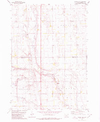 1979 Fraser Dam1980 Print · USGSAgricultural life in Jerauld and Aurora Counties is captured here in the late seventies as local townships managed the prairie landscape. Genealogists can locate family-named landmarks like Piersons Draw and community sites including Solberg Cem and Fraser Dam.
 - 1979 Map of New Holland, 1980 Print
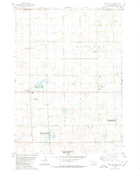 1979 New Holland1980 Print · USGSDouglas County farm country is captured here in the late seventies, showing the established communities of New Holland and Harrison. Researchers can trace local roots at Ebenezer Ch or locate the Markus Sch and Beukelman Sch schoolhouses.
 - 1979 Map of Laffey Lake, 1980 Print
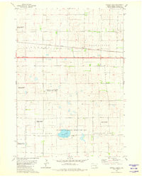
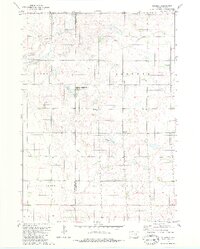
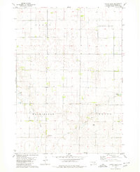 1979 Laffey Lake1980 Print · USGSAurora County's agricultural heartland is documented here in the late seventies, showing the established township grids and prairie waterways. Researchers can trace land divisions across Gales and Center or locate landmarks like Laffey Lake.
 - 1979 Map of Crystal Lake, 1980 Print
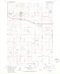
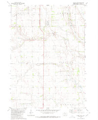
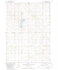
 1979 Crystal Lake1980 Print · USGSAurora County's prairie wetlands and conservation areas are documented here during the late 1970s. Researchers can trace the path of the Chicago Milwaukee St Paul and Pacific railroad and locate landmarks like Crystal Lake and the Flowing Well.
 - 1979 Map of White Lake, 1980 Print
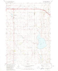
 1979 White Lake1980 Print · USGSWhite Lake and the surrounding Aurora County prairie are captured here in the late seventies as a landscape of rail transit and wildlife conservation. Genealogists and historians can trace the Chicago Milwaukee St Paul and Pacific rail line or locate the Crystal Lake Cem near White Lake.
 - 1979 Map of Platte Lake, 1980 Print
 1979 Platte Lake1980 Print · USGSAcross the Brule and Aurora county line in the late seventies, this survey captures a landscape of prairie lakes and transition. Genealogists and historians can trace rural landmarks like the Wilbur Center Sch or the grounds of the Lake Sixteen State Public Shooting Area.
 - 1979 Map of Aurora Center, 1980 Print
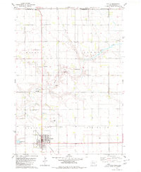
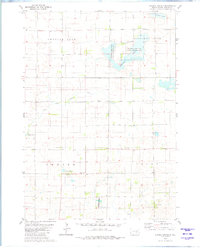 1979 Aurora Center1980 Print · USGSAurora County's prairie landscape in the late 1970s is defined by its vast public shooting areas and scattered wetlands. Researchers can locate the Quaker Cem, explore the shores of Crystal Lake, and trace the small community of Aurora Center.
 - 1979 Map of Joubert, 1980 Print
 1979 Joubert1980 Print · USGSThe rural prairie of Douglas and Aurora counties is captured here in the late seventies, showing a landscape shaped by agriculture and water management. Researchers can locate the Clark-Joubert Sch, the Townhall, and conserved lands in the National Waterfowl Production Area.
 - 1979 Map of Platte, 1980 Print
 1979 Platte1980 Print · USGSCharles Mix County thrived as a railroad-anchored agricultural center during the late seventies. Genealogists and local historians can trace the foundations of the community through sites like Platte, the C M St P & P rail line, and the Swedish Lutheran Cem.
 - 1979 Map of Storla SW, 1980 Print
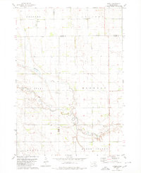
 1979 Storla SW1980 Print · USGSAurora County’s rural prairie landscape is captured here in the late seventies, showing the transition of its township lands. Researchers can locate the local Townhall and trace the drainage of Firesteel Creek near the National Waterfowl Production Area.
 - 1979 Map of Storla, 1980 Print
 1979 Storla1980 Print · USGSThe crossroads of Aurora, Sanborn, and Davison counties are documented here in the late seventies. Family historians can trace the rural community of Storla and its surrounding landmarks like Trinity Ch, Blendon Sch, and Knutson Cem.
 - 1979 Map of Twin Lakes, 1980 Print
 1979 Twin Lakes1980 Print · USGSSanborn County and its neighboring borderlands appear here in the late seventies, centered on the vital prairie waters of the James River Valley region. Researchers can locate rural landmarks like Belford Sch, Elliott Sch, and the Twin Lakes State Recreation Area.
End of results
Showing maps 1-13 of 13
Frequently asked questions
- What are the different types of historical maps available for Aurora County?
- What is the oldest map of Aurora County?
- Where can I purchase historical maps of Aurora County for my home or office?
- Where can I download high-res historical maps of Aurora County?
- Are there historical topographic maps available for Aurora County?
- Is there historical aerial imagery available for Aurora County?
- Where are historical maps of Aurora County sourced from?