1940s Maps of Aurora County, South Dakota
Explore 2 historic maps of Aurora County from the 1940s. These maps offer a rare glimpse into what life looked like during the 1940s — showing old roads, neighborhoods, homes, and landmarks that have changed or disappeared over time.
Whether you're researching your family's past, planning a metal detecting trip, or studying how Aurora County's landscape evolved across the 1940s, these high-resolution maps are a powerful tool for exploring the history of this region.
- Focus on a specific era: All maps on this page are from the 1940s, giving you a focused view of this time period.
- See what’s changed: Compare century-old streets, trails, and buildings to today's modern landscape using overlays and satellite layers.
- Research with precision: Use these maps for genealogy, historical research, land use analysis, or educational projects.
- View, download, or print: Maps are fully viewable online in high resolution, and can be downloaded or printed for your own records.
Start exploring Aurora County's history through authentic maps from the 1940s. This is your window into the past.
Aurora County, SD maps
(2)- 1941 Map of Kimball North
 1941 Kimball North1941 Print · USGSBrule County's agricultural heartland is documented here on the eve of the Second World War, showing a landscape defined by rail and rural schools. Genealogists can trace family footprints near Kimball or locate specific country schools like Fagerhaug Sch and Brooks Sch.
 - 1942 Map of Crow Lake
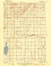 1942 Crow Lake1942 Print · USGSThe South Dakota prairie of Jerauld and Aurora Counties is captured here in the early 1940s, showing a landscape defined by small townships and artesian wells. Genealogists can trace a dense network of rural landmarks, including Underwood Ch, Union Cem, and numerous schoolhouses like Willow Bend Sch.3 unique versions available
End of results
Showing maps 1-2 of 2
Frequently asked questions
- What are the different types of historical maps available for Aurora County?
- What is the oldest map of Aurora County?
- Where can I purchase historical maps of Aurora County for my home or office?
- Where can I download high-res historical maps of Aurora County?
- Are there historical topographic maps available for Aurora County?
- Is there historical aerial imagery available for Aurora County?
- Where are historical maps of Aurora County sourced from?