1900s (20th Century) Maps of Huron, South Dakota
Explore 7 historic maps of Huron from the 1900s (20th Century). These maps offer a rare glimpse into what life looked like during the 1900s — showing old roads, neighborhoods, homes, and landmarks that have changed or disappeared over time.
Whether you're researching your family's past, planning a metal detecting trip, or studying how Huron's landscape evolved across the 1900s, these high-resolution maps are a powerful tool for exploring the history of this region.
- Focus on a specific era: All maps on this page are from the 1900s, giving you a focused view of this time period.
- See what’s changed: Compare century-old streets, trails, and buildings to today's modern landscape using overlays and satellite layers.
- Research with precision: Use these maps for genealogy, historical research, land use analysis, or educational projects.
- View, download, or print: Maps are fully viewable online in high resolution, and can be downloaded or printed for your own records.
Start exploring Huron's history through authentic maps from the 1900s. This is your window into the past.
Huron, SD maps
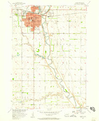
(7)- 1953 Map of Huron, 1959 Print
 1953 Huron1959 Print · USGSCentral South Dakota comes alive in the mid-1950s as a thriving rail and agricultural corridor between the Missouri and James Rivers. Trace the legacy of family farms and prairie towns like Huron, Faulkton, and Wessington Springs along the historic Chicago and North Western rail lines.3 unique versions available
 - 1954 Map of Huron, 1977 Print
 1954 Huron1977 Print · USGSCentral South Dakota was a landscape of grain elevators and river bends during the mid-fifties. Genealogists and historians can trace the development of the James River valley through railroad towns like Redfield and the sprawling Crow Creek Indian Reservation.
 - 1957 Map of Huron, 1958 Print
 1957 Huron1958 Print · USGSHuron and the James River valley are captured in the late fifties as the city expanded around its rail and river roots. Genealogists and historians can trace neighborhood developments like Morningside or locate landmarks such as Huron College and Riverside Cemetery.2 unique versions available
 - 1958 Map of Huron NW, 1959 Print
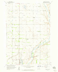 1958 Huron NW1959 Print · USGSBeadle County rural life in the late fifties is defined by the winding James River and a scattering of Hutterite and pioneer-era legacy sites. Researchers can trace the consolidation of local education through several one-room schoolhouses, including Edison Sch and Whittier Sch, alongside the communal Riverside Colony.2 unique versions available
 - 1973 Map of Broadland, 1976 Print
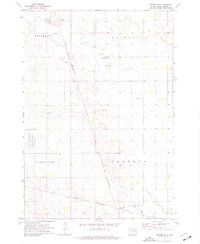 1973 Broadland1976 Print · USGSBeadle County in the early seventies is mapped here as a network of rail lines and agricultural townships. Genealogists and local historians can trace the Chicago and North Western corridor through Broadland and past the Townhall in Hartland.
 - 1973 Map of Wolsey SE, 1976 Print
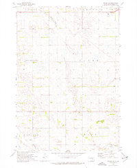 1973 Wolsey SE1976 Print · USGSBeadle County farmland at the start of the 1970s is shown here in high detail, from the small community of Carlyle to the rural Townhall. Genealogists and researchers can trace township lines and water features like Schwartz Slough or Cain Creek.
 - 1985 Map of Huron, 1986 Print
 1985 Huron1986 Print · USGSThe James River valley and the city of Huron come into focus during the mid-eighties as centers of rail and prairie commerce. Genealogists and historians can trace communal sites like Riverside Colony and established rail towns from Wolsey to Woonsocket.2 unique versions available
End of results
Showing maps 1-7 of 7
Top cities near Huron
- Alpena historical maps
- Cavour historical maps
- Yale historical maps
- Broadland historical maps
- Virgil historical maps
Frequently asked questions
- What are the different types of historical maps available for Huron?
- What is the oldest map of Huron?
- Where can I purchase historical maps of Huron for my home or office?
- Where can I download high-res historical maps of Huron?
- Are there historical topographic maps available for Huron?
- Is there historical aerial imagery available for Huron?
- Where are historical maps of Huron sourced from?