1900s (20th Century) Maps of Vale, South Dakota
Explore 7 historic maps of Vale from the 1900s (20th Century). These maps offer a rare glimpse into what life looked like during the 1900s — showing old roads, neighborhoods, homes, and landmarks that have changed or disappeared over time.
Whether you're researching your family's past, planning a metal detecting trip, or studying how Vale's landscape evolved across the 1900s, these high-resolution maps are a powerful tool for exploring the history of this region.
- Focus on a specific era: All maps on this page are from the 1900s, giving you a focused view of this time period.
- See what’s changed: Compare century-old streets, trails, and buildings to today's modern landscape using overlays and satellite layers.
- Research with precision: Use these maps for genealogy, historical research, land use analysis, or educational projects.
- View, download, or print: Maps are fully viewable online in high resolution, and can be downloaded or printed for your own records.
Start exploring Vale's history through authentic maps from the 1900s. This is your window into the past.
Vale, SD maps
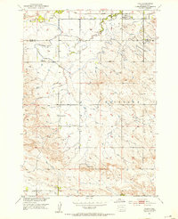
(7)- 1906 Map of Vale
 1906 Vale1906 Print · USGSThe high plains of western South Dakota are captured here in the early twentieth century as ranching and river-fed agriculture began to take root. Researchers can trace the early footprints of Vale and Butte Hall along the winding Belle Fourche River.2 unique versions available
 - 1913 Map of Newell
 1913 Newell1913 Print · USGSButte and Meade Counties were being reshaped by new rails and irrigation projects in the decade before the Great War. Researchers can trace the path of the Chicago and Northwestern Ry and locate early settlements like Newell, Vale, and Station Elm.2 unique versions available
 - 1951 Map of Vale, 1953 Print
 1951 Vale1953 Print · USGSVale and the surrounding Butte County ranchlands are captured in the early fifties during the expansion of the Missouri River Basin irrigation network. Researchers can trace the Chicago and North Western rail line and locate early landmarks like Old Vale Cem and the Wagner Historical Monument.3 unique versions available
 - 1951 Map of Vale, 1959 Print
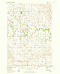 1951 Vale1959 Print · USGSThe Butte and Meade county line in the early fifties shows a landscape of irrigated prairies and river bends shaped by the Belle Fourche River. Genealogists and local historians can trace rural school districts like Plainview Sch and find family sites near Vale Cem or the Chicago and North Western rail line.
 - 1953 Map of Rapid City, 1964 Print
 1953 Rapid City1964 Print · USGSWestern South Dakota's transition from the Black Hills to the open prairie is captured here during the mid-fifties. Researchers can trace the development of Ellsworth Air Force Base alongside historic landmarks like Bear Butte and the Lower Alkali School.3 unique versions available
 - 1957 Map of Rapid City
 1957 Rapid City1957 Print · USGSWestern South Dakota in the mid-fifties reveals a landscape of high-altitude forests and growing military installations. Researchers can trace the development of Ellsworth Air Force Base, locate the Theodore Roosevelt Monument, and find rural landmarks like Lower Alkali School.
 - 1983 Map of Belle Fourche
 1983 Belle Fourche1983 Print · USGSWestern South Dakota's ranching and irrigation systems are well-established in this early 1980s survey. Researchers can trace historic family holdings like McClure Ranch and the path of the Chicago and North Western railroad near Belle Fourche.
End of results
Showing maps 1-7 of 7
Top cities near Vale
Frequently asked questions
- What are the different types of historical maps available for Vale?
- What is the oldest map of Vale?
- Where can I purchase historical maps of Vale for my home or office?
- Where can I download high-res historical maps of Vale?
- Are there historical topographic maps available for Vale?
- Is there historical aerial imagery available for Vale?
- Where are historical maps of Vale sourced from?