1970s Maps of Bryan Township, South Dakota
Explore 4 historic maps of Bryan Township from the 1970s. These maps offer a rare glimpse into what life looked like during the 1970s — showing old roads, neighborhoods, homes, and landmarks that have changed or disappeared over time.
Whether you're researching your family's past, planning a metal detecting trip, or studying how Bryan Township's landscape evolved across the 1970s, these high-resolution maps are a powerful tool for exploring the history of this region.
- Focus on a specific era: All maps on this page are from the 1970s, giving you a focused view of this time period.
- See what’s changed: Compare century-old streets, trails, and buildings to today's modern landscape using overlays and satellite layers.
- Research with precision: Use these maps for genealogy, historical research, land use analysis, or educational projects.
- View, download, or print: Maps are fully viewable online in high resolution, and can be downloaded or printed for your own records.
Start exploring Bryan Township's history through authentic maps from the 1970s. This is your window into the past.
Bryan Township, SD maps
(4)- 1972 Map of Dante, 1974 Print
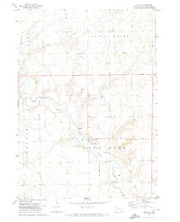 1972 Dante1974 Print · USGSDante and the surrounding prairies of the Yankton Indian Reservation are captured here in the early 1970s. Local researchers can trace the Old Indian Treaty Boundary and locate family sites near United Cem and the Dante rail line.
 - 1977 Map of Wagner
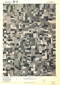 1977 Wagner1977 Print · USGSWagner and the surrounding farmlands of Charles Mix County are seen from the air in the late seventies. Family historians and researchers can trace the precise layout of Wagner and the winding path of Choteau Creek across the prairie.
 - 1977 Map of Wagner NE
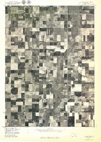 1977 Wagner NE1977 Print · USGSCharles Mix County agriculture is captured in detail during the late seventies, showing the intricate grid of rural land management. Trace the winding course of Choteau Creek and the development of local farmsteads across this agricultural landscape.
 - 1978 Map of Greenwood Colony, 1979 Print
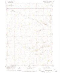 1978 Greenwood Colony1979 Print · USGSThe Douglas and Charles Mix county line in the late 1970s shows a landscape of reservation boundaries and rural prairie settlements. Researchers can trace the layout of Greenwood Colony and find local landmarks such as St Pauls Ch and New Salem Cem.
End of results
Showing maps 1-4 of 4
Top cities near Bryan Township
- Wagner historical maps
- Armour historical maps
- Avon historical maps
- Delmont historical maps
- Pickstown historical maps
- Dante historical maps
See more
Frequently asked questions
- What are the different types of historical maps available for Bryan Township?
- What is the oldest map of Bryan Township?
- Where can I purchase historical maps of Bryan Township for my home or office?
- Where can I download high-res historical maps of Bryan Township?
- Are there historical topographic maps available for Bryan Township?
- Is there historical aerial imagery available for Bryan Township?
- Where are historical maps of Bryan Township sourced from?