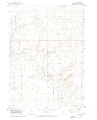
1972 Map of Dante
USGS Topo · Published 1974About this map
Dante stands as the central hub in this prairie landscape of Choteau Creek, situated within the boundaries of the Yankton Indian Reservation. The settlement pattern is defined by the Chicago Milwaukee St Paul and Pacific railroad, which cuts diagonally across the township lines of Bryan, Lawrence, and Lone Tree. A significant historical landmark is the Old Indian Treaty Boundary, which runs through the western section of the map, marking a legacy of land division and tribal sovereignty.
Find a feature on this map
11 named features on this map. Tap any name to fly to it.
Don’t see what you’re looking for? This feature index may not catch every label — zoom into the map to look around manually.
Map Details
Editions of this 1972 Dante Map
This is the sole edition of this map. No revisions or reprints were ever made.
Other maps of this area

1955 · Mitchell
USGS Topo · 1:250,000

1955 · O'Neill
USGS Topo · 1:250,000

1959 · O'Neill
USGS Topo · 1:250,000

1959 · Mitchell
USGS Topo · 1:250,000

1964 · Wagner NE
USGS Topo · 1:24,000

1964 · Wagner
USGS Topo · 1:24,000

1964 · Lynch NE
USGS Topo · 1:24,000

1969 · O'Neill
USGS Topo · 1:250,000
1972 · Niobrara NW
USGS Topo · 1:24,000

1977 · Oak Hollow
USGS Topo · 1:24,000