1977 Map of Oak Hollow
USGS Topo · Published 1977About this map
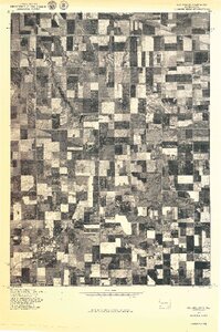
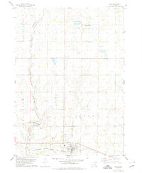
Tripp Lake provides a central landmark for this orthophotoquad, which captures the agricultural geometry of Hutchinson County in the late 1970s. Produced in cooperation with the Bureau of Indian Affairs, this imagery-based study reveals the intricate drainage patterns of Oak Hollow as it cuts through the sectioned farmland. Unlike a standard topographic line drawing, this aerial perspective highlights the exact placement of farmsteads, shelterbelts, and localized water management features that defined the rural South Dakota landscape during this era. The fine-grained contrast between tilled fields and natural vegetation along the hollow offers a direct look at how the plains were being actively managed and partitioned.
Find a feature on this map
2 named features on this map. Tap any name to fly to it.
Don’t see what you’re looking for? This feature index may not catch every label — zoom into the map to look around manually.
Map Details
Editions of this 1977 Oak Hollow Map
This is the sole edition of this map. No revisions or reprints were ever made.
Other maps of this area

1898 · Olivet
USGS Topo · 1:125,000

1955 · Sioux Falls
USGS Topo · 1:250,000

1955 · Mitchell
USGS Topo · 1:250,000

1958 · Sioux Falls
USGS Topo · 1:250,000

1959 · Mitchell
USGS Topo · 1:250,000
1972 · Dante
USGS Topo · 1:24,000
1978 · Oak Hollow
USGS Topo · 1:24,000
1978 · Haucks Lake
USGS Topo · 1:24,000
1978 · Avon
USGS Topo · 1:24,000
1978 · Greenwood Colony
USGS Topo · 1:24,000
Featured Places
- Choteau Creek Township, SD
- East Choteau Township, SD
- Oak Hollow Township, SD
- Monroe Township, SD
- Bon Homme County, SD