1970s Maps of Ree Township, South Dakota
Explore 1 historic maps of Ree Township from the 1970s. These maps offer a rare glimpse into what life looked like during the 1970s — showing old roads, neighborhoods, homes, and landmarks that have changed or disappeared over time.
Whether you're researching your family's past, planning a metal detecting trip, or studying how Ree Township's landscape evolved across the 1970s, these high-resolution maps are a powerful tool for exploring the history of this region.
- Focus on a specific era: All maps on this page are from the 1970s, giving you a focused view of this time period.
- See what’s changed: Compare century-old streets, trails, and buildings to today's modern landscape using overlays and satellite layers.
- Research with precision: Use these maps for genealogy, historical research, land use analysis, or educational projects.
- View, download, or print: Maps are fully viewable online in high resolution, and can be downloaded or printed for your own records.
Start exploring Ree Township's history through authentic maps from the 1970s. This is your window into the past.
Ree Township, SD maps
(1)- 1972 Map of Niobrara NW, 1974 Print
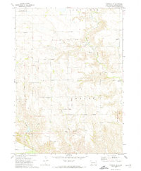 1972 Niobrara NW1974 Print · USGSCharles Mix County in the early 1970s reveals a rural landscape defined by the Old Indian Treaty Boundary and the Yankton Indian Reservation. Genealogists and historians can trace community centers like Holy Name Ch, School No 73, and local Flowing Wells.
End of results
Showing maps 1-1 of 1
Top cities near Ree Township
- Wagner historical maps
- Avon historical maps
- Lynch historical maps
- Dante historical maps
- Ravinia historical maps
- Verdel historical maps
See more
Frequently asked questions
- What are the different types of historical maps available for Ree Township?
- What is the oldest map of Ree Township?
- Where can I purchase historical maps of Ree Township for my home or office?
- Where can I download high-res historical maps of Ree Township?
- Are there historical topographic maps available for Ree Township?
- Is there historical aerial imagery available for Ree Township?
- Where are historical maps of Ree Township sourced from?