1960s Maps of Riverside Township, South Dakota
Explore 4 historic maps of Riverside Township from the 1960s. These maps offer a rare glimpse into what life looked like during the 1960s — showing old roads, neighborhoods, homes, and landmarks that have changed or disappeared over time.
Whether you're researching your family's past, planning a metal detecting trip, or studying how Riverside Township's landscape evolved across the 1960s, these high-resolution maps are a powerful tool for exploring the history of this region.
- Focus on a specific era: All maps on this page are from the 1960s, giving you a focused view of this time period.
- See what’s changed: Compare century-old streets, trails, and buildings to today's modern landscape using overlays and satellite layers.
- Research with precision: Use these maps for genealogy, historical research, land use analysis, or educational projects.
- View, download, or print: Maps are fully viewable online in high resolution, and can be downloaded or printed for your own records.
Start exploring Riverside Township's history through authentic maps from the 1960s. This is your window into the past.
Riverside Township, SD maps
(4)- 1968 Map of Wakonda, 1971 Print
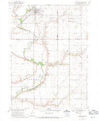
 1968 Wakonda1971 Print · USGSDakota farmland near Wakonda comes into focus during the late sixties, revealing the organized grid of townships and rural waterways. Genealogists and historians can trace family locations near Columkill Cem, Holland Cem, and the quiet crossroads of Colfax Corner.
 - 1968 Map of Centerville, 1971 Print
 1968 Centerville1971 Print · USGSCenterville was a bustling agricultural hub in the late sixties, where the railroad and the Vermillion River intersect. Genealogists can trace family roots through the rural townships to find Ivey Sch, Komstad Ch, and Hovde Cem.
 - 1969 Map of Hub City, 1971 Print
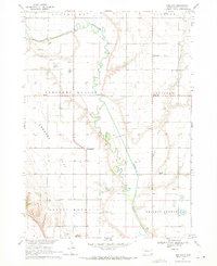 1969 Hub City1971 Print · USGSClay County farming life in the late sixties is centered here on the winding Vermillion River. Genealogists can trace ancestral sites at Lodi Cem, the Dalesburg Sch, and the landmark Spirit Mound.
 - 1969 Map of Gayville NE, 1971 Print
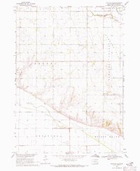 1969 Gayville NE1971 Print · USGSClay County's rural townships are captured here in the late sixties, showcasing a landscape of section-line roads and family-centered landmarks. Genealogists can trace property roots through features like Westreville, St Patricks Cem, and the historic townhall.
End of results
Showing maps 1-4 of 4
Top cities near Riverside Township
- Beresford historical maps
- Centerville historical maps
- Viborg historical maps
- Gayville historical maps
- Wakonda historical maps
- Meckling historical maps
See more
Top neighborhoods of Riverside Township
Frequently asked questions
- What are the different types of historical maps available for Riverside Township?
- What is the oldest map of Riverside Township?
- Where can I purchase historical maps of Riverside Township for my home or office?
- Where can I download high-res historical maps of Riverside Township?
- Are there historical topographic maps available for Riverside Township?
- Is there historical aerial imagery available for Riverside Township?
- Where are historical maps of Riverside Township sourced from?