1970s Maps of Fuller Township, South Dakota
Explore 3 historic maps of Fuller Township from the 1970s. These maps offer a rare glimpse into what life looked like during the 1970s — showing old roads, neighborhoods, homes, and landmarks that have changed or disappeared over time.
Whether you're researching your family's past, planning a metal detecting trip, or studying how Fuller Township's landscape evolved across the 1970s, these high-resolution maps are a powerful tool for exploring the history of this region.
- Focus on a specific era: All maps on this page are from the 1970s, giving you a focused view of this time period.
- See what’s changed: Compare century-old streets, trails, and buildings to today's modern landscape using overlays and satellite layers.
- Research with precision: Use these maps for genealogy, historical research, land use analysis, or educational projects.
- View, download, or print: Maps are fully viewable online in high resolution, and can be downloaded or printed for your own records.
Start exploring Fuller Township's history through authentic maps from the 1970s. This is your window into the past.
Fuller Township, SD maps
(3)- 1970 Map of Still Lake, 1973 Print
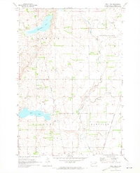 1970 Still Lake1973 Print · USGSCodington County's prairie landscape is captured here in the early 1970s, showcasing a meticulously surveyed network of township sections and watercourses. Researchers can locate the Esterly Cem, trace the Sisseton Indian Reservation Boundary, and see the rural Townhall.
 - 1973 Map of Florence, 1976 Print
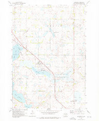 1973 Florence1976 Print · USGSThe town of Florence and its prairie pothole landscape are captured here in the early 1970s. Local researchers can trace the Chicago and North Western rail line and locate family landmarks like Dexter Cem and Helger Cem.
 - 1973 Map of Kampeska, 1978 Print
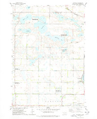 1973 Kampeska1978 Print · USGSCodington County in the early seventies shows a landscape defined by glacial lakes and conservation areas west of the growing hub of Watertown. Genealogists and outdoor historians can trace old property lines and landmarks like Kampeska, Lynwood State Public Access Area, and the Chicago and North Western line.
End of results
Showing maps 1-3 of 3
Top cities near Fuller Township
- Watertown historical maps
- Rauville historical maps
- Florence historical maps
- Kampeska historical maps
- Henry historical maps
- Wallace historical maps
Top neighborhoods of Fuller Township
Frequently asked questions
- What are the different types of historical maps available for Fuller Township?
- What is the oldest map of Fuller Township?
- Where can I purchase historical maps of Fuller Township for my home or office?
- Where can I download high-res historical maps of Fuller Township?
- Are there historical topographic maps available for Fuller Township?
- Is there historical aerial imagery available for Fuller Township?
- Where are historical maps of Fuller Township sourced from?