1960s Maps of Corson County, South Dakota
Explore 15 historic maps of Corson County from the 1960s. These maps offer a rare glimpse into what life looked like during the 1960s — showing old roads, neighborhoods, homes, and landmarks that have changed or disappeared over time.
Whether you're researching your family's past, planning a metal detecting trip, or studying how Corson County's landscape evolved across the 1960s, these high-resolution maps are a powerful tool for exploring the history of this region.
- Focus on a specific era: All maps on this page are from the 1960s, giving you a focused view of this time period.
- See what’s changed: Compare century-old streets, trails, and buildings to today's modern landscape using overlays and satellite layers.
- Research with precision: Use these maps for genealogy, historical research, land use analysis, or educational projects.
- View, download, or print: Maps are fully viewable online in high resolution, and can be downloaded or printed for your own records.
Start exploring Corson County's history through authentic maps from the 1960s. This is your window into the past.
Corson County, SD maps
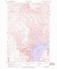
(15)- 1965 Map of Pollock SE, 1967 Print
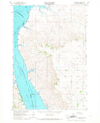 1965 Pollock SE1967 Print · USGSThe Missouri River and Oahe Reservoir dominate the landscape of Campbell County in the mid-1960s. Researchers can trace the Standing Rock Indian Reservation Boundary across the water or locate family history at Gale Cem and Kvarness Cem.2 unique versions available
 - 1966 Map of Mahto NE, 1967 Print
 1966 Mahto NE1967 Print · USGSThe Missouri River borderlands in the mid-1960s reveal a landscape shaped by the rising Oahe Reservoir. Genealogists and historians can trace the Standing Rock Indian Reservation Boundary and drainage at Fireheart Creek and Blackfoot Creek.2 unique versions available
 - 1966 Map of McLaughlin, 1967 Print
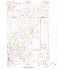
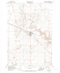 1966 McLaughlin1967 Print · USGSMcLaughlin and the surrounding plains of Corson County are captured here in the mid-1960s as a vital railroad town. Researchers can trace the town's footprint along the Chicago Milwaukee St Paul and Pacific line, locating the Protestant Cem and the local Landing Strip.2 unique versions available
 - 1966 Map of McLaughlin NE, 1967 Print
 1966 McLaughlin NE1967 Print · USGSThe high plains along the state line between the Dakotas are captured here during the mid-sixties. Genealogists and local historians can trace the Chicago Milwaukee St Paul and Pacific rail line and the location of the Goose Camp Sch.
 - 1966 Map of Mahto, 1967 Print
 1966 Mahto1967 Print · USGSCorson County's rolling prairie landscape is captured here in the mid-sixties, centered on the small siding at Mahto. Local historians can trace the path of the Chicago Milwaukee St Paul and Pacific railroad as it follows Oak Creek past a local Gravel Pit.
 - 1966 Map of Kenel, 1967 Print
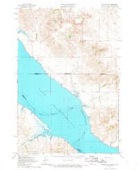
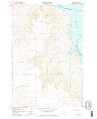 1966 Kenel1967 Print · USGSThe Missouri River breaks along the eastern edge of the Standing Rock Indian Reservation during the mid-1960s. Genealogists and historians can trace the local community at Kenel through landmarks like St Benedict Ch and the Kenel Sch.2 unique versions available
 - 1966 Map of Mahto NW, 1967 Print
 1966 Mahto NW1967 Print · USGSThe borderlands of the Dakotas appear here in the mid-1960s, showing the intersection of Sioux Co and Corson Co. Researchers can locate the Hope Cem and trace the winding paths of Bush Creek and Blackfoot Creek through Lincoln township.
 - 1966 Map of Kline Buttes, 1967 Print
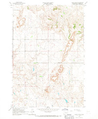 1966 Kline Buttes1967 Print · USGSCorson County land during the mid-sixties reveals a landscape defined by its high prairie terrain and isolated rural institutions. Researchers can trace early school district locations like Butte Sch and topographical landmarks such as Lonesome Butte or Kellers Dam.
 - 1966 Map of Pollock NW, 1967 Print
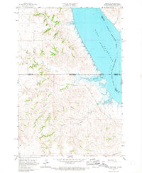
 1966 Pollock NW1967 Print · USGSThe Missouri River valley undergoes a massive transition in the mid-1960s as the Oahe Reservoir fills the landscape. Researchers can trace the submerged riverbanks and the Standing Rock Indian Reservation Boundary alongside landmarks like Dale Cem.
 - 1967 Map of Glenham, 1968 Print
 1967 Glenham1968 Print · USGSWalworth County in the late sixties reveals a landscape transformed by the Missouri River's damming and the steady pulse of the rail line. Genealogists and researchers can trace the rural Habenberg Sch, the rail siding at Ridgeland, and the shoreline of the Oahe Reservoir.
 - 1967 Map of Mobridge NE, 1969 Print
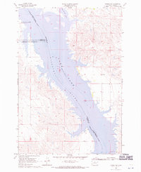
 1967 Mobridge NE1969 Print · USGSThe Missouri River valley undergoes a massive transformation in the late sixties as the reservoir fills the canyon between Campbell and Corson Counties. Trace the historical Standing Rock Indian Reservation Boundary and the upland terrain of Wakpala above the Oahe Reservoir.2 unique versions available
 - 1967 Map of Mobridge NW, 1969 Print
 1967 Mobridge NW1969 Print · USGSThe Missouri River breaks in the late sixties reveal a landscape transformed by the Oahe Reservoir along the Standing Rock Indian Reservation Boundary. Trace the shoreline to find the Leavenworth Monument, Fisher Creek, and the upland terrain of Wakpala.
 - 1967 Map of Mobridge, 1969 Print
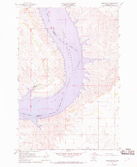
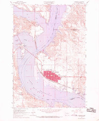 1967 Mobridge1969 Print · USGSMobridge and the Missouri River corridor are captured here during the late sixties as the reservoir transformed the regional landscape. Researchers can locate Sitting Bulls Grave, trace the Chicago Milwaukee St Paul and Pacific rail line, and find local landmarks like Greenwood Cem or Beadle Sch.2 unique versions available
 - 1968 Map of Moreau NW, 1970 Print
 1968 Moreau NW1970 Print · USGSThe Missouri and Moreau River valleys are captured in the late sixties as the landscape adjusted to the rising waters of Lake Oahe. Researchers can trace the shifting shorelines of Lake Missouri and follow the boundary between the Standing Rock and Cheyenne River Indian Reservations.
 - 1968 Map of Moreau NE, 1970 Print
 1968 Moreau NE1970 Print · USGSThe Missouri River breaks of Walworth and Dewey counties appear in the late sixties as the waters of Lake Oahe reshape the valley. Genealogists and researchers can trace the boundaries of the Standing Rock and Cheyenne River reservations or locate the settlement at Ridgeland.
End of results
Showing maps 1-15 of 15
Top cities of Corson County
Frequently asked questions
- What are the different types of historical maps available for Corson County?
- What is the oldest map of Corson County?
- Where can I purchase historical maps of Corson County for my home or office?
- Where can I download high-res historical maps of Corson County?
- Are there historical topographic maps available for Corson County?
- Is there historical aerial imagery available for Corson County?
- Where are historical maps of Corson County sourced from?