1970s Maps of Enemy Swim District, South Dakota
Explore 14 historic maps of Enemy Swim District from the 1970s. These maps offer a rare glimpse into what life looked like during the 1970s — showing old roads, neighborhoods, homes, and landmarks that have changed or disappeared over time.
Whether you're researching your family's past, planning a metal detecting trip, or studying how Enemy Swim District's landscape evolved across the 1970s, these high-resolution maps are a powerful tool for exploring the history of this region.
- Focus on a specific era: All maps on this page are from the 1970s, giving you a focused view of this time period.
- See what’s changed: Compare century-old streets, trails, and buildings to today's modern landscape using overlays and satellite layers.
- Research with precision: Use these maps for genealogy, historical research, land use analysis, or educational projects.
- View, download, or print: Maps are fully viewable online in high resolution, and can be downloaded or printed for your own records.
Start exploring Enemy Swim District's history through authentic maps from the 1970s. This is your window into the past.
Enemy Swim District, SD maps
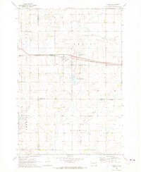
(14)- 1970 Map of Summit, 1973 Print
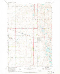 1970 Summit1973 Print · USGSThe town of Summit and the high prairie wetlands are captured here in the early 1970s. Trace the path of the CHICAGO MILWAUKEE ST PAUL AND PACIFIC railroad through the Sisseton Indian Reservation Boundary and past the Summit Cem.
 - 1970 Map of Lonesome Lake, 1973 Print
 1970 Lonesome Lake1973 Print · USGSThe rural landscape of eastern South Dakota in the early 1970s is meticulously captured here where Grant and Day counties meet. Genealogists and local historians can locate the Bergen Ch and Cem, alongside geographical markers like Lonesome Lake and the Big Sioux River.
 - 1970 Map of Summit NE, 1973 Print
 1970 Summit NE1973 Print · USGSNortheastern Roberts County in the early seventies reveals a landscape of glacial coulees and scattered prairie lakes. Genealogists can locate Old Ascension Cem and Ascension Ch near the deep drainage of Big Coulee.
 - 1970 Map of Still Lake SE, 1973 Print
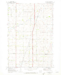
 1970 Still Lake SE1973 Print · USGSCodington County in the early 1970s is shown here as a landscape of grid-patterned townships and prairie drainage. Genealogists can locate family landmarks like St Johns Ch, Townhall, and the Henricks Landing Strip along the Burlington Northern line.
 - 1970 Map of Waubay, 1973 Print
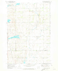
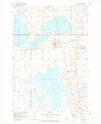 1970 Waubay1973 Print · USGSThe glacial lake region of Day County is captured here in the early 1970s, centered on the settlement of Waubay. Genealogists and local historians can locate Old Zion Cem, trace the Sisseton Indian Reservation Boundary, and see the extent of Bitter Lake.
 - 1970 Map of Piyas Lake, 1973 Print
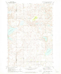
 1970 Piyas Lake1973 Print · USGSMarshall and Day counties in the early 1970s reveal a landscape of glacial lakes and prairie townships. Trace family roots and local landmarks from Buffalo Lake Ch to the seasonal developments at Pickerel Lake State Park and the Church Camp.
 - 1970 Map of Florence NE, 1973 Print
 1970 Florence NE1973 Print · USGSThe Coteau des Prairies of northeastern South Dakota is captured here in the early 1970s, showing a landscape of sprawling wetlands and high-prairie townships. Researchers can locate the Egeland Cem and Egeland Ch, or trace the Sisseton Indian Reservation Boundary near Goose Lake.
 - 1970 Map of Enemy Swim Lake East, 1973 Print
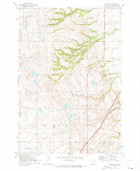
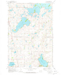
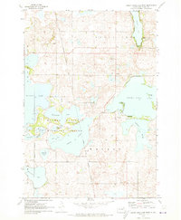
 1970 Enemy Swim Lake East1973 Print · USGSRoberts and Day County lands within the Sisseton Indian Reservation are captured here during the 1970s. Local researchers can map out rural intersections like Rudebusch Corner or trace the shorelines of Enemy Swim Lake and Hurricane Lake.
 - 1970 Map of Ortley, 1973 Print
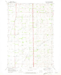
 1970 Ortley1973 Print · USGSOrtley and the surrounding prairie of Roberts County are captured here in the early 1970s, as the railroad still defined the local economy. Genealogists can locate family landmarks like Hope Ch, the Townhall, and the steel rails of the Chicago Milwaukee St Paul and Pacific.
 - 1970 Map of Drywood Lakes, 1973 Print
 1970 Drywood Lakes1973 Print · USGSThe Sisseton Indian Reservation in the early 1970s is characterized by its expansive prairie lakes and rural parish communities across Marshall and Roberts counties. Genealogists and local historians can locate remote landmarks like Zuark Ch, Buffalo Lake Ch, and the Townhall site.
 - 1970 Map of Enemy Swim Lake West, 1973 Print
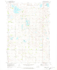
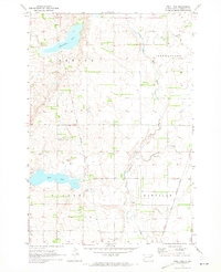
 1970 Enemy Swim Lake West1973 Print · USGSThe glacial lakes of the Sisseton Indian Reservation are shown in detail during the early 1970s. Researchers can locate the St Joseph Ch Cem, the Blue Dog (Grave), and the extensive Waubay National Wildlife Refuge.
 - 1970 Map of Still Lake NE, 1973 Print
 1970 Still Lake NE1973 Print · USGSThe eastern South Dakota plains come into focus in the early 1970s, showing the rural townships of Grant and Codington counties. Researchers can trace the Sisseton Indian Reservation Boundary or locate the local St Johns Ch and Townhall.
 - 1970 Map of Still Lake, 1973 Print
 1970 Still Lake1973 Print · USGSCodington County's prairie landscape is captured here in the early 1970s, showcasing a meticulously surveyed network of township sections and watercourses. Researchers can locate the Esterly Cem, trace the Sisseton Indian Reservation Boundary, and see the rural Townhall.
 - 1979 Map of Sisseton, 1980 Print
 1979 Sisseton1980 Print · USGSNortheastern South Dakota and the North Dakota borderlands appear here in the late seventies, centered on the high glacial plateau. Genealogists and historians can trace the Sisseton Indian Reservation and rail-stop towns like Britton and Lake City.
End of results
Showing maps 1-14 of 14
Top cities near Enemy Swim District
- Waubay historical maps
- Florence historical maps
- Summit historical maps
- Spring Grove historical maps
- Grenville historical maps
- Ortley historical maps
Top neighborhoods of Enemy Swim District
- Enemy Swim historical maps
- Sunrise Hutterite Colony historical maps
- Rudebusch Corner historical maps
- Ortley historical maps
Frequently asked questions
- What are the different types of historical maps available for Enemy Swim District?
- What is the oldest map of Enemy Swim District?
- Where can I purchase historical maps of Enemy Swim District for my home or office?
- Where can I download high-res historical maps of Enemy Swim District?
- Are there historical topographic maps available for Enemy Swim District?
- Is there historical aerial imagery available for Enemy Swim District?
- Where are historical maps of Enemy Swim District sourced from?