1970s Maps of Milbank, South Dakota
Explore 2 historic maps of Milbank from the 1970s. These maps offer a rare glimpse into what life looked like during the 1970s — showing old roads, neighborhoods, homes, and landmarks that have changed or disappeared over time.
Whether you're researching your family's past, planning a metal detecting trip, or studying how Milbank's landscape evolved across the 1970s, these high-resolution maps are a powerful tool for exploring the history of this region.
- Focus on a specific era: All maps on this page are from the 1970s, giving you a focused view of this time period.
- See what’s changed: Compare century-old streets, trails, and buildings to today's modern landscape using overlays and satellite layers.
- Research with precision: Use these maps for genealogy, historical research, land use analysis, or educational projects.
- View, download, or print: Maps are fully viewable online in high resolution, and can be downloaded or printed for your own records.
Start exploring Milbank's history through authentic maps from the 1970s. This is your window into the past.
Milbank, SD maps
(2)- 1973 Map of Milbank West, 1976 Print
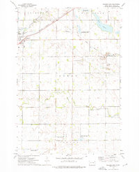
 1973 Milbank West1976 Print · USGSMilbank and the surrounding Grant County townships are captured here in the early 1970s, as the railroad and river systems defined the local economy. Researchers can trace the layout of Milbank and locate rural landmarks such as Township Cem and St Lawrence Sch.
 - 1973 Map of Milbank East, 1976 Print
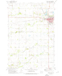
 1973 Milbank East1976 Print · USGSMilbank was a bustling rail and quarrying hub in the early 1970s, situated where the prairie meets the Whetstone River. Genealogists and historians can trace the Old Indian Treaty Boundary or locate family sites near St Lawrence Cem and the Bethlehem Ch.
End of results
Showing maps 1-2 of 2
Top cities near Milbank
- Ortonville historical maps
- Big Stone City historical maps
- Wilmot historical maps
- Marietta historical maps
- Revillo historical maps
- Foster historical maps
See more
Frequently asked questions
- What are the different types of historical maps available for Milbank?
- What is the oldest map of Milbank?
- Where can I purchase historical maps of Milbank for my home or office?
- Where can I download high-res historical maps of Milbank?
- Are there historical topographic maps available for Milbank?
- Is there historical aerial imagery available for Milbank?
- Where are historical maps of Milbank sourced from?