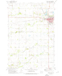
1973 Map of Milbank West
USGS Topo · Published 1976About this map
The Chicago Milwaukee St Paul and Pacific railroad forms a vital corridor through eastern South Dakota, anchoring the city of Milbank. This 1973 survey details a transition from the structured urban grid of the town to the surrounding agricultural townships of Grant Center and Alban. The landscape is defined by the winding paths of the South Fork Whetstone River in the north and the Yellow Bank River system to the south, where the drainage patterns influenced early rural development.
Find a feature on this map
34 named features on this map. Tap any name to fly to it.
Don’t see what you’re looking for? This feature index may not catch every label — zoom into the map to look around manually.
Map Details
Editions of this 1973 Milbank West Map
This is the sole edition of this map. No revisions or reprints were ever made.
Other maps of this area

1953 · Milbank
USGS Topo · 1:250,000

1954 · Big Stone Lake
USGS Topo · 1:62,500

1958 · Milbank
USGS Topo · 1:250,000

1971 · Corona
USGS Topo · 1:24,000

1971 · Big Stone Lake SE
USGS Topo · 1:24,000

1971 · Big Stone Lake SW
USGS Topo · 1:24,000

1973 · Twin Brooks
USGS Topo · 1:24,000

1973 · LaBolt
USGS Topo · 1:24,000

1973 · Stockholm
USGS Topo · 1:24,000
1973 · Revillo
USGS Topo · 1:24,000