1980s Maps of Milk's Camp Segment, South Dakota
Explore 2 historic maps of Milk's Camp Segment from the 1980s. These maps offer a rare glimpse into what life looked like during the 1980s — showing old roads, neighborhoods, homes, and landmarks that have changed or disappeared over time.
Whether you're researching your family's past, planning a metal detecting trip, or studying how Milk's Camp Segment's landscape evolved across the 1980s, these high-resolution maps are a powerful tool for exploring the history of this region.
- Focus on a specific era: All maps on this page are from the 1980s, giving you a focused view of this time period.
- See what’s changed: Compare century-old streets, trails, and buildings to today's modern landscape using overlays and satellite layers.
- Research with precision: Use these maps for genealogy, historical research, land use analysis, or educational projects.
- View, download, or print: Maps are fully viewable online in high resolution, and can be downloaded or printed for your own records.
Start exploring Milk's Camp Segment's history through authentic maps from the 1980s. This is your window into the past.
Milk's Camp Segment, SD maps
(2)- 1986 Map of Winner
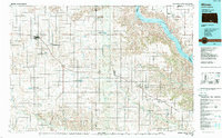 1986 Winner1986 Print · USGSTripp and Gregory Counties are captured in the mid-eighties as the agricultural heartland centered on the Chicago and North Western line. Genealogists can trace family footprints near St Charles, Paxton, and Winner, or explore the shoreline of Lake Francis Case.2 unique versions available
 - 1986 Map of Lake Andes
 1986 Lake Andes1986 Print · USGSThe Yankton Indian Reservation and the vast Missouri River impoundments define this South Dakota landscape in the mid-eighties. Researchers can trace old township lines and the Old Railroad Grade, or locate sites like Fort Randall and the Pleasant Ridge Cem.3 unique versions available
End of results
Showing maps 1-2 of 2
Top cities near Milk's Camp Segment
Frequently asked questions
- What are the different types of historical maps available for Milk's Camp Segment?
- What is the oldest map of Milk's Camp Segment?
- Where can I purchase historical maps of Milk's Camp Segment for my home or office?
- Where can I download high-res historical maps of Milk's Camp Segment?
- Are there historical topographic maps available for Milk's Camp Segment?
- Is there historical aerial imagery available for Milk's Camp Segment?
- Where are historical maps of Milk's Camp Segment sourced from?