1970s Maps of Harding County, South Dakota
Explore 36 historic maps of Harding County from the 1970s. These maps offer a rare glimpse into what life looked like during the 1970s — showing old roads, neighborhoods, homes, and landmarks that have changed or disappeared over time.
Whether you're researching your family's past, planning a metal detecting trip, or studying how Harding County's landscape evolved across the 1970s, these high-resolution maps are a powerful tool for exploring the history of this region.
- Focus on a specific era: All maps on this page are from the 1970s, giving you a focused view of this time period.
- See what’s changed: Compare century-old streets, trails, and buildings to today's modern landscape using overlays and satellite layers.
- Research with precision: Use these maps for genealogy, historical research, land use analysis, or educational projects.
- View, download, or print: Maps are fully viewable online in high resolution, and can be downloaded or printed for your own records.
Start exploring Harding County's history through authentic maps from the 1970s. This is your window into the past.
Harding County, SD maps
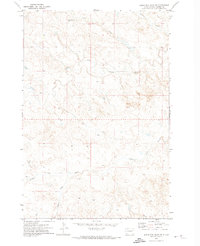
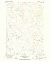
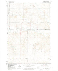
(36)- 1971 Map of Buffalo, 1974 Print
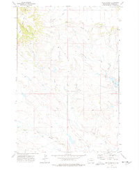
 1971 Buffalo1974 Print · USGSBuffalo and its surrounding prairie are captured here in the early seventies, centered on the South Fork Grand River. Researchers can trace local landmarks like the Harding County Airport, Lake Gardner, and the Buffalo Cemetery.
 - 1971 Map of Sheep Pen Draw, 1974 Print
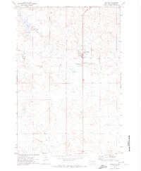
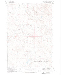
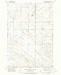
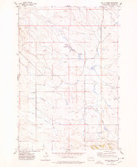
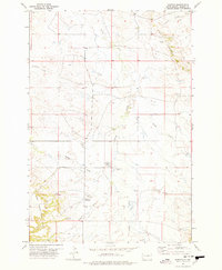
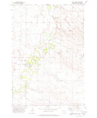
 1971 Sheep Pen Draw1974 Print · USGSThe high plains of Harding County are captured here in the early seventies, just after field checks by the USGS. Researchers can trace rural landmarks and drainage patterns along Sheep Pen Draw, the Stensland Landing Strip, and the Grand River.
 - 1971 Map of Lahti Butte, 1974 Print
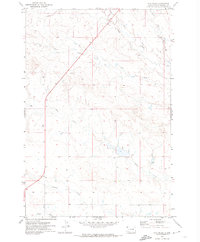
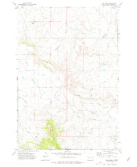
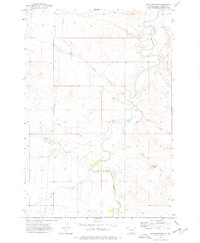
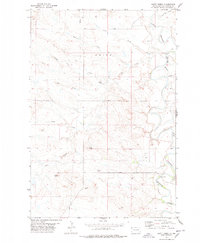
 1971 Lahti Butte1974 Print · USGSIn the early 1970s, this area of Harding County was a landscape of expansive rangeland and isolated landmarks like Lahti Butte. Researchers can trace the drainage patterns of Jones Creek or locate local aviation history at the Travers Landing Strip.
 - 1971 Map of McKenzie Butte, 1974 Print
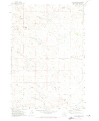
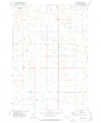
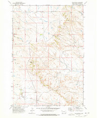
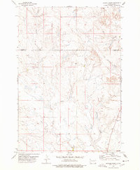
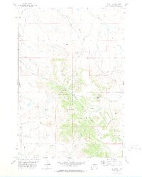
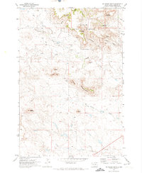 1971 McKenzie Butte1974 Print · USGSHarding County’s high butte country is captured here in the early 1970s, during a time of quiet ranching and resource extraction. Genealogists and historians can locate the Cave Hills Church, the Hilton Mine, and remote family landmarks like Van Offern Butte.2 unique versions available
 - 1971 Map of Sheep Pen Draw SW, 1974 Print
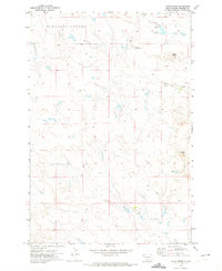
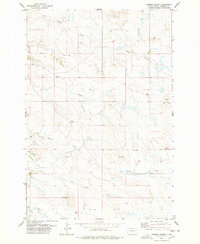
 1971 Sheep Pen Draw SW1974 Print · USGSHarding County’s high prairie and river breaks are captured here in the early seventies, showing a landscape of remote ranchlands and winding watercourses. Researchers can locate the Old Grand River Cem and trace the paths of the South Fork Grand River and Clarks Fork.
 - 1971 Map of Sheep Pen Draw SE, 1974 Print
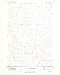
 1971 Sheep Pen Draw SE1974 Print · USGSNorthwestern South Dakota's open range and river forks are captured here in the early 1970s. Trace the expansive grounds of the State Experiment Farm and Antelope Reserve and the convergence of Clarks Fork and the Grand River.
 - 1971 Map of Hay Creek, 1974 Print
 1971 Hay Creek1974 Print · USGSHarding County rangeland comes into focus during the early 1970s, showing the vast grazing lands of South Dakota before modern development. Genealogists and historians can trace old property boundaries and drainage networks along Hay Creek, Jones Creek, and State Route 85.
 - 1971 Map of Saddle Butte, 1974 Print
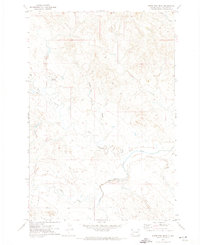
 1971 Saddle Butte1974 Print · USGSHarding County, South Dakota, is captured in the early seventies as a vast ranching landscape defined by the winding South Fork Grand River. Researchers can locate the Grand River Cem and trace aviation history at the Lamphere-Thompson Landing Strip.
 - 1973 Map of Lone Tree Draw East, 1977 Print
 1973 Lone Tree Draw East1977 Print · USGSWestern South Dakota's ranching country is captured here in the early 1970s at the intersection of Butte and Harding Counties. Researchers can trace local landmarks like St Anthony Cem and the drainages of Sand Creek and Lone Tree Draw.
 - 1973 Map of Lone Tree Draw West, 1977 Print
 1973 Lone Tree Draw West1977 Print · USGSThe northern range of South Dakota is captured here in the early seventies, spanning the border of Harding and Butte counties. Researchers can trace the watercourses of South Fork Moreau River or locate landmarks like Crow Buttes and Macy Butte.
 - 1973 Map of Bog Creek, 1978 Print
 1973 Bog Creek1978 Print · USGSHarding County, South Dakota, is captured here in the early seventies, showcasing a landscape defined by dramatic geological breaks and massive river watersheds. Researchers can locate Ruona Ranch or trace the winding path of The Jumpoff and Bog Creek.
 - 1973 Map of Redig, 1978 Print
 1973 Redig1978 Print · USGSHarding County ranching country is mapped here in the early 1970s, showcasing the remote prairie life of northwest South Dakota. Genealogists and local historians can locate the Redig Sch, Redig Cem, and the high point at Saddle Butte.
 - 1973 Map of Hells Canyon, 1978 Print
 1973 Hells Canyon1978 Print · USGSHarding County ranching country appears in the early 1970s as a landscape of remote outposts and river drainages. Researchers can trace the layout of the Dunn Ranch, locate a lone Landing Strip, and follow the winding path of the South Fork Moreau River.
 - 1973 Map of Gallup Creek, 1978 Print
 1973 Gallup Creek1978 Print · USGSHarding County ranching and remote prairie life are documented in this early 1970s survey of the South Dakota plains. Researchers can locate the Bullock Community Center, trace the seasonal flow of Smiley Creek, and identify the secluded Alma Cem.
 - 1974 Map of Caroline Butte, 1976 Print
 1974 Caroline Butte1976 Print · USGSHarding County ranch lands are documented here in the mid-1970s, showing a remote landscape shaped by the Little Missouri River. Researchers can trace the rural layout of Tarter Ranch and locate landmarks like Caroline Butte and Smiley Creek.
 - 1974 Map of Pine Spring, 1977 Print
 1974 Pine Spring1977 Print · USGSHarding County ranching country is documented here in the mid-seventies, showing the dramatic terrain of The Jumpoff. Researchers can trace old fence lines and water sources like Buffalo Springs and Cundy Reservoir.
 - 1974 Map of Cow Butte, 1978 Print
 1974 Cow Butte1978 Print · USGSThe Dakota borderlands come into focus in the mid-1970s at the intersection of four counties. Genealogists and local historians can locate rural landmarks like Mamre Ch and Golden Valley Ch Cem along the North Fork Grand River.
 - 1977 Map of Harding
 1977 Harding1977 Print · USGSHarding and the West Short Pine Hills are captured in the late seventies during a period of steady ranching and rural life. Researchers can find precise locations for the Brant School, Short Pine Cem, and the distinctive terrain of The Jump Off.
 - 1977 Map of Scott Creek, 1978 Print
 1977 Scott Creek1978 Print · USGSThe northwest corner of South Dakota is shown in the late 1970s as a landscape of winding river bends and high plains buttes. Researchers can trace ranching and transit history through features like Salmen Ford on the Little Missouri River and landmarks such as Bleak Butte and Profile Butte.
 - 1977 Map of Doaks Butte, 1978 Print
 1977 Doaks Butte1978 Print · USGSThe North Dakota and South Dakota borderlands meet along the Little Missouri River in this late seventies survey. Map collectors can trace the high plains terrain around Doaks Butte and locate local landmarks like the Gravel Pit and Soda Creek.
 - 1977 Map of Granger Creek, 1978 Print
 1977 Granger Creek1978 Print · USGSButte and Harding Counties appear in the late 1970s as a landscape of isolated rangeland and intricate drainage networks. Local historians can trace the rural infrastructure of the era, from the Cottonwood Sch to scattered sites like the Drill Hole and Well.
 - 1977 Map of Camp Crook, 1978 Print
 1977 Camp Crook1978 Print · USGSCamp Crook and the surrounding Harding County range appear here in the late seventies, centered on the winding Little Missouri River. Researchers can trace the layout of the Catron Ranch, locate the Fairview Cem, or find the Hoag Coal Mine Draw.
 - 1978 Map of Chimney Butte
 1978 Chimney Butte1978 Print · USGSHarding County ranching country is captured here in the late seventies, showing a landscape of scattered wells and high buttes. Local historians and genealogists can locate the Ladner Cem, Hoiland Cem, and landmarks like Chimney Butte.
 - 1978 Map of J K Butte
 1978 J K Butte1978 Print · USGSHarding County ranching and forest lands are captured here in the late seventies, showing a landscape of high buttes and isolated homesteads. Researchers can locate the Davis Ranch, trace the West Short Pine Hills, and identify early Drill Hole sites.
 - 1978 Map of Redig NE
 1978 Redig NE1978 Print · USGSHarding County ranching country is captured in the late 1970s as a landscape defined by its vital waterways and open range. Researchers can trace the winding paths of the North Fork Moreau River and Clarks Fork Creek or locate landmarks like Diamond along Route 85.
Showing maps 1-25 of 36
Top cities of Harding County
Frequently asked questions
- What are the different types of historical maps available for Harding County?
- What is the oldest map of Harding County?
- Where can I purchase historical maps of Harding County for my home or office?
- Where can I download high-res historical maps of Harding County?
- Are there historical topographic maps available for Harding County?
- Is there historical aerial imagery available for Harding County?
- Where are historical maps of Harding County sourced from?