Old Maps of Harding County, South Dakota for Hiking & Exploration
Hike through history with 416 historic maps of Harding County. Explore old trails, ghost towns, and forgotten backroads — perfect for outdoor adventurers and local explorers.
- Rediscover forgotten places: Map out old mining camps, roads, and footpaths that no longer exist on modern maps.
- Layer with modern tools: Combine with LiDAR or satellite views to plan hikes through historical terrain.
- Made for exploration: Popular among hikers, overlanders, and local history lovers.
Use these maps to find adventure and explore the hidden past of Harding County.
Harding County, SD maps
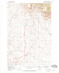
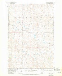
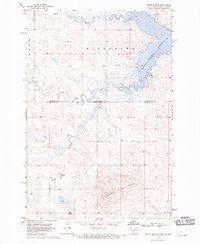
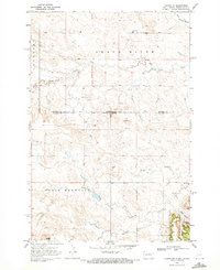
(416)- 1935 Map of Reva
 1935 Reva1935 Print · USGSHarding County ranching country and the rugged Slim Buttes region are captured here in the mid-1930s. Genealogists and local historians can trace family-named landmarks like Turkey Track Ranch and early post offices at Reva, Ludlow, and Glenlevit.
 - 1935 Map of Hoover
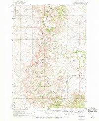
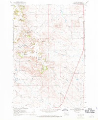
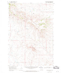
 1935 Hoover1935 Print · USGSThe high plains of South Dakota in the mid-thirties reveal a landscape of remote ranching outposts and conservation lands. Genealogists and researchers can trace family-named landmarks like JB Ranch and early settlements such as Hoover and Murchison.
 - 1935 Map of Harding
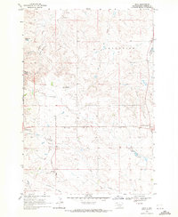
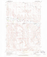
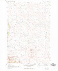
 1935 Harding1935 Print · USGSNorthwestern South Dakota in the mid-1930s was a vast expanse of range land where local life centered on the Custer National Forest and isolated outposts. Genealogists and historians can trace the early road networks and rural hubs like Harding, Gustave, and Mud Butte along the banks of the North Fork Moreau River.
 - 1935 Map of Buffalo
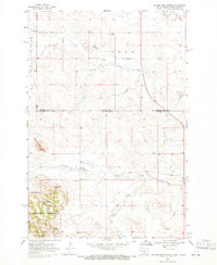
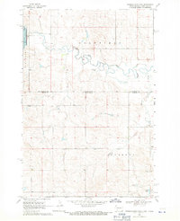
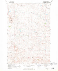
 1935 Buffalo1935 Print · USGSHarding County in the mid-1930s remains a wide-open landscape where the early road system connects remote prairie outposts. Genealogists and historians can locate early settlements like Camp Crook and Bullock or trace the drainages of the Little Missouri River and South Fork Grand River.
 - 1954 Map of Lemmon, 1964 Print
 1954 Lemmon1964 Print · USGSThe high plains of South Dakota and North Dakota are documented here during the mid-twentieth century. Family researchers can trace dozens of country school sites like Green Cabin School and Bierke School alongside landmarks like The Castles.2 unique versions available
 - 1954 Map of Ekalaka, 1966 Print
 1954 Ekalaka1966 Print · USGSSoutheastern Montana and its borderlands with the Dakotas and Wyoming appear here in the mid-fifties, showing a remote ranching landscape. Genealogists can trace family roots through numerous rural landmarks like the Sherwin School, St Marys Ch, and Powderville.3 unique versions available
 - 1956 Map of Ekalaka
 1956 Ekalaka1956 Print · USGSSoutheast Montana and the Wyoming borderlands are shown here in the mid-fifties, capturing a landscape of remote ranching outposts and isolated country schools. Genealogists can trace family roots through landmarks like Boyes, Alzada, and Peabody School.
 - 1957 Map of Lemmon
 1957 Lemmon1957 Print · USGSThe northwestern plains of South Dakota and North Dakota are captured here in the mid-fifties, centered on the rail hub of Lemmon. Genealogists and historians can trace dozens of rural schoolhouses and vanished sites like Imogene and the Shadehill Reservoir area.
 - 1958 Map of Ekalaka
 1958 Ekalaka1958 Print · USGSSoutheast Montana in the mid-fifties remains a landscape of isolated ranching outposts and scattered schoolhouses. Genealogists and researchers can trace rural life through landmarks like Belltower, the McClary Ranger Station, and numerous family-named schools such as Davidson School.
 - 1965 Map of Ekalaka
 1965 Ekalaka1965 Print · USGSThe High Plains of Montana and Wyoming appear here in the mid-1950s, as a sprawling landscape of remote ranchlands and rural school districts. Researchers can trace the locations of many small landmarks like Mitchell School, Broadus, and the Humbolt Hills.
 - 1968 Map of Irish Butte, 1971 Print
 1968 Irish Butte1971 Print · USGSNorthwestern South Dakota's ranching country in the late sixties is defined here by the high ridges of the Slim Buttes and the remote Custer National Forest. Researchers can trace old rural infrastructure like the Goyett Sch and family landmarks such as Horton Ranch and Houk Spring.
 - 1968 Map of J B Hill, 1971 Print
 1968 J B Hill1971 Print · USGSHarding County ranching and the high plateaus of the Slim Buttes are documented here in the late sixties. Genealogists and local historians can trace family landholdings like Rock Ranch and Thybo Ranch or locate the old Rock Ranch Sch.
 - 1968 Map of Reva, 1971 Print
 1968 Reva1971 Print · USGSHarding County ranching country is captured here in the late sixties as the community of Reva remained a quiet hub for the surrounding plains. Genealogists and local historians can trace family-named landmarks like McPherson Spring and find the Slim Buttes Ch.
 - 1968 Map of Eagles Nest Butte, 1971 Print
 1968 Eagles Nest Butte1971 Print · USGSThe high plains of the Dakotas meet at the border in the late 1960s, where the river valley gives way to timbered forest and prominent buttes. Researchers can trace the early foundations of the ranching economy through landmarks like the Grand River Cem, Lone Tree Sch, and McCumsey Spring.
 - 1968 Map of Ralph SW, 1971 Print
 1968 Ralph SW1971 Print · USGSHarding County in the late 1960s was a landscape defined by small rural schools and essential water management for ranching. Genealogists can locate family-named features and landmarks like Lincoln Sch, Immanuel Ch, and Sarsland Lake.
 - 1968 Map of Haley, 1971 Print
 1968 Haley1971 Print · USGSThe North Dakota and South Dakota borderlands come alive in this late 1960s survey of the High Plains. Genealogists and local historians can trace the rural landscape of Haley and locate landmarks like the Haley Sch, the local Cem, and Wilson Creek.
 - 1968 Map of Bowman-Haley Dam, 1971 Print
 1968 Bowman-Haley Dam1971 Print · USGSThe North Dakota and South Dakota borderlands come into focus in the late sixties, where the newly formed reservoir meets the winding river valley. Trace the locations of rural community life at Haley Cem, St Isidore Cem, and the Vessey Sch near the quiet waters of Vessey Lake.
 - 1968 Map of Ludlow, 1971 Print
 1968 Ludlow1971 Print · USGSHarding County ranching and forest lands are captured in the late sixties as the region balanced conservation and extraction. Genealogists and researchers can locate the Ludlow settlement, Ludlow Cave, and numerous family-named landmarks like Rileys Butte and Jenkins Spring No 1.
 - 1968 Map of Tepee Buttes, 1971 Print
 1968 Tepee Buttes1971 Print · USGSThe North Dakota and South Dakota borderlands are captured here in the late sixties as the Bowman-Haley Reservoir fills the valley. Genealogists and local historians can locate early landmarks such as Grave and Corey Butte.
 - 1968 Map of Sheep Mountain, 1971 Print
 1968 Sheep Mountain1971 Print · USGSHarding County’s high plains and the northern reaches of the Slim Buttes are shown here as they appeared in the late sixties. Researchers can trace vital water sources and early land boundaries across Sheep Mountain, Willard Gap, and numerous named sites like Moonshine Spring.
 - 1968 Map of Flat Top Butte, 1971 Print
 1968 Flat Top Butte1971 Print · USGSHarding County ranching land and the northern reaches of the Custer National Forest are captured here during the late sixties. Genealogists and historians can trace the paths of HOOVER ROAD, find the local Cem, and locate landmarks like Flat Top Butte.
 - 1968 Map of Ludlow SE, 1971 Print
 1968 Ludlow SE1971 Print · USGSHarding County ranching country is captured here in the late sixties, showing the remote landscape before modern development. Researchers can find old property lines, the Lanesboro Sch, and local landmarks like Ashcroft Butte and Big Nasty Creek.2 unique versions available
 - 1968 Map of Ralph, 1971 Print
 1968 Ralph1971 Print · USGSHarding County ranching country is shown in the late sixties, centered on the community of Ralph. Researchers can trace rural landmarks like St Isadore Ch, Southwest Sch, and the winding Big Nasty Creek.
 - 1969 Map of Ladner NE, 1971 Print
 1969 Ladner NE1971 Print · USGSThe high plains of Harding County and Bowman County are captured here in the late sixties, showing a landscape of sprawling ranchlands and prominent mesas. Researchers can locate the Grand River Sch, the remote Cox Ch, and landmarks like Table Mountain.
 - 1969 Map of Battleship Rock, 1971 Print
 1969 Battleship Rock1971 Print · USGSHarding County ranching and forest lands are captured here during the late sixties, where the towering Slim Buttes meet the open plains. Researchers can locate local landmarks like Battleship Rock, family operations at Helms Ranch, and the remote Ivers Mine.
Showing maps 1-25 of 416
Top cities of Harding County
Frequently asked questions
- What are the different types of historical maps available for Harding County?
- What is the oldest map of Harding County?
- Where can I purchase historical maps of Harding County for my home or office?
- Where can I download high-res historical maps of Harding County?
- Are there historical topographic maps available for Harding County?
- Is there historical aerial imagery available for Harding County?
- Where are historical maps of Harding County sourced from?