1980s Maps of Jackson County, South Dakota
Explore 11 historic maps of Jackson County from the 1980s. These maps offer a rare glimpse into what life looked like during the 1980s — showing old roads, neighborhoods, homes, and landmarks that have changed or disappeared over time.
Whether you're researching your family's past, planning a metal detecting trip, or studying how Jackson County's landscape evolved across the 1980s, these high-resolution maps are a powerful tool for exploring the history of this region.
- Focus on a specific era: All maps on this page are from the 1980s, giving you a focused view of this time period.
- See what’s changed: Compare century-old streets, trails, and buildings to today's modern landscape using overlays and satellite layers.
- Research with precision: Use these maps for genealogy, historical research, land use analysis, or educational projects.
- View, download, or print: Maps are fully viewable online in high resolution, and can be downloaded or printed for your own records.
Start exploring Jackson County's history through authentic maps from the 1980s. This is your window into the past.
Jackson County, SD maps
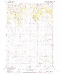
(11)- 1980 Map of Kadoka
 1980 Kadoka1980 Print · USGSWestern South Dakota's open plains and Badlands are captured here in the early eighties, showcasing a region defined by its railroads and reservations. Researchers can trace the routes of the Chicago and North Western or locate local landmarks like Kadoka Lake and Wanblee.
 - 1981 Map of Cedar Butte
 1981 Cedar Butte1981 Print · USGSThe South Dakota prairie at the start of the eighties is captured here, detailing the rural landscape of Mellette and Jackson counties. Local researchers can trace family landmarks and community sites like Stands For Them Cem, Running Bird Sch, and St Thomas Ch.
 - 1981 Map of Long Valley
 1981 Long Valley1981 Print · USGSWestern South Dakota's open range is captured here in the early eighties, showing the interface between Jackson County and the Pine Ridge Indian Reservation. Researchers can locate the Hawkwing Cemetery, the Rodeo Ground, and the small settlement of Long Valley.
 - 1981 Map of Wall
 1981 Wall1981 Print · USGSWestern South Dakota in the early eighties reveals a landscape of high tables and deep draws where the prairie meets the Badlands. Researchers can trace the path of the Chicago and North Western rail line and locate rural outposts like Scenic, Conata, and Interior.
 - 1981 Map of Broken Leg Dam
 1981 Broken Leg Dam1981 Print · USGSThe Pine Ridge Indian Reservation in Jackson County is shown here in the mid-1970s, as ranching and water management shaped the landscape. Researchers can trace local infrastructure through features like Broken Leg Dam, Poor Bear Lake, and the curiously named Up Settin Creek.
 - 1981 Map of Kyle
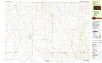 1981 Kyle1981 Print · USGSThe Pine Ridge Indian Reservation is documented here in the early 1980s, centered on the community of Kyle. Local historians can trace the path of the Big Foot Trail and locate landmarks like the Little Wound Sch and St Barnabas Ch.
 - 1981 Map of Short Bow Creek
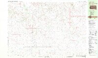 1981 Short Bow Creek1981 Print · USGSJackson County ranchlands and reservation territory are captured here during the early eighties. Genealogists and historians can trace the essential water sources of the prairie, from Hooks Spring to landmarks like Half Dome and Berry Dam.
 - 1981 Map of Hisle
 1981 Hisle1981 Print · USGSThe Pine Ridge Indian Reservation and the rural landscapes of Jackson County are captured in this early 1980s survey. Genealogists can locate St Joseph Cem and trace the small community of Hisle along the banks of Bear-in-the-Lodge Creek.
 - 1981 Map of Buzzard Butte
 1981 Buzzard Butte1981 Print · USGSThe Pine Ridge Indian Reservation in Jackson and Bennett counties is captured here in the early eighties as a landscape of dramatic buttes and winding creeks. Genealogists and historians can trace the paths of Bear-in-the-Lodge Creek and landmarks like Eagle Nest Butte.
 - 1983 Map of Martin
 1983 Martin1983 Print · USGSBennett County and the neighboring tribal lands appear here in the early eighties as a network of High Plains settlements and conservation areas. Researchers can trace tribal boundaries and local genealogy through sites like Pine Ridge Indian Reservation, Long Valley, and Arnold Ranch.
 - 1985 Map of Pine Ridge
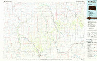 1985 Pine Ridge1985 Print · USGSThe Pine Ridge Indian Reservation and the edge of the Badlands are detailed in this mid-eighties survey of the South Dakota-Nebraska border. Researchers can trace the drainages of Wounded Knee Creek and White River to locate landmarks like Red Dog Table and Wounded Knee.2 unique versions available
End of results
Showing maps 1-11 of 11
Top cities of Jackson County
- Kadoka historical maps
- Interior historical maps
- Belvidere historical maps
- Weta historical maps
- Cottonwood historical maps
Frequently asked questions
- What are the different types of historical maps available for Jackson County?
- What is the oldest map of Jackson County?
- Where can I purchase historical maps of Jackson County for my home or office?
- Where can I download high-res historical maps of Jackson County?
- Are there historical topographic maps available for Jackson County?
- Is there historical aerial imagery available for Jackson County?
- Where are historical maps of Jackson County sourced from?