1980s Maps of Spearfish, South Dakota
Explore 2 historic maps of Spearfish from the 1980s. These maps offer a rare glimpse into what life looked like during the 1980s — showing old roads, neighborhoods, homes, and landmarks that have changed or disappeared over time.
Whether you're researching your family's past, planning a metal detecting trip, or studying how Spearfish's landscape evolved across the 1980s, these high-resolution maps are a powerful tool for exploring the history of this region.
- Focus on a specific era: All maps on this page are from the 1980s, giving you a focused view of this time period.
- See what’s changed: Compare century-old streets, trails, and buildings to today's modern landscape using overlays and satellite layers.
- Research with precision: Use these maps for genealogy, historical research, land use analysis, or educational projects.
- View, download, or print: Maps are fully viewable online in high resolution, and can be downloaded or printed for your own records.
Start exploring Spearfish's history through authentic maps from the 1980s. This is your window into the past.
Spearfish, SD maps
(2)- 1983 Map of Belle Fourche
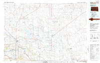 1983 Belle Fourche1983 Print · USGSWestern South Dakota's ranching and irrigation systems are well-established in this early 1980s survey. Researchers can trace historic family holdings like McClure Ranch and the path of the Chicago and North Western railroad near Belle Fourche.
 - 1984 Map of Chicken Creek, 1985 Print
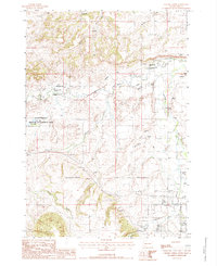 1984 Chicken Creek1985 Print · USGSThe confluence of Redwater River and Spearfish Creek highlights this mid-1980s South Dakota landscape. Researchers can trace land use through the Abandoned Canal, Clay Pits, and the Higgins settlement.
End of results
Showing maps 1-2 of 2
Top cities near Spearfish
- Belle Fourche historical maps
- Lead historical maps
- North Spearfish historical maps
- Deadwood historical maps
- Whitewood historical maps
- Mountain Plains historical maps
See more
Top neighborhoods of Spearfish
Frequently asked questions
- What are the different types of historical maps available for Spearfish?
- What is the oldest map of Spearfish?
- Where can I purchase historical maps of Spearfish for my home or office?
- Where can I download high-res historical maps of Spearfish?
- Are there historical topographic maps available for Spearfish?
- Is there historical aerial imagery available for Spearfish?
- Where are historical maps of Spearfish sourced from?