1960s Maps of Fairview Township, South Dakota
Explore 3 historic maps of Fairview Township from the 1960s. These maps offer a rare glimpse into what life looked like during the 1960s — showing old roads, neighborhoods, homes, and landmarks that have changed or disappeared over time.
Whether you're researching your family's past, planning a metal detecting trip, or studying how Fairview Township's landscape evolved across the 1960s, these high-resolution maps are a powerful tool for exploring the history of this region.
- Focus on a specific era: All maps on this page are from the 1960s, giving you a focused view of this time period.
- See what’s changed: Compare century-old streets, trails, and buildings to today's modern landscape using overlays and satellite layers.
- Research with precision: Use these maps for genealogy, historical research, land use analysis, or educational projects.
- View, download, or print: Maps are fully viewable online in high resolution, and can be downloaded or printed for your own records.
Start exploring Fairview Township's history through authentic maps from the 1960s. This is your window into the past.
Fairview Township, SD maps
(3)- 1962 Map of Canton, 1964 Print
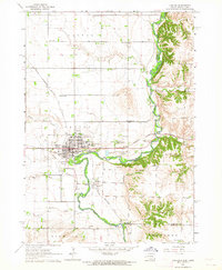 1962 Canton1964 Print · USGSThe South Dakota and Iowa border comes alive in the early sixties as the Big Sioux River winds past bustling prairie towns. Genealogists can locate several rural schools and cemeteries, including Augustana Academy, Beloit Cem, and York Sch.2 unique versions available
 - 1968 Map of Alcester NE, 1970 Print
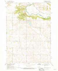 1968 Alcester NE1970 Print · USGSThe Big Sioux River valley comes to life in the late sixties as it winds through Lincoln County. Genealogists can trace early rural life through family-named landmarks like Moe Sch, Bethany Cem, and the tracks of the Chicago Milwaukee St Paul and Pacific railroad.2 unique versions available
 - 1968 Map of Fairview, 1971 Print
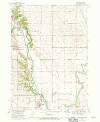 1968 Fairview1971 Print · USGSThe Big Sioux River valley straddles the South Dakota and Iowa border in the late sixties, a landscape of river-bend farms and rail-line towns. Local historians can trace the Milwaukee Road tracks past Fairview and the Blanchard Sch.
End of results
Showing maps 1-3 of 3
Top cities near Fairview Township
- Harrisburg historical maps
- Rock Valley historical maps
- Canton historical maps
- Hawarden historical maps
- Inwood historical maps
- Alcester historical maps
See more
Top neighborhoods of Fairview Township
Frequently asked questions
- What are the different types of historical maps available for Fairview Township?
- What is the oldest map of Fairview Township?
- Where can I purchase historical maps of Fairview Township for my home or office?
- Where can I download high-res historical maps of Fairview Township?
- Are there historical topographic maps available for Fairview Township?
- Is there historical aerial imagery available for Fairview Township?
- Where are historical maps of Fairview Township sourced from?