1900s (20th Century) Maps of Lyman County, South Dakota
Explore 67 historic maps of Lyman County from the 1900s (20th Century). These maps offer a rare glimpse into what life looked like during the 1900s — showing old roads, neighborhoods, homes, and landmarks that have changed or disappeared over time.
Whether you're researching your family's past, planning a metal detecting trip, or studying how Lyman County's landscape evolved across the 1900s, these high-resolution maps are a powerful tool for exploring the history of this region.
- Focus on a specific era: All maps on this page are from the 1900s, giving you a focused view of this time period.
- See what’s changed: Compare century-old streets, trails, and buildings to today's modern landscape using overlays and satellite layers.
- Research with precision: Use these maps for genealogy, historical research, land use analysis, or educational projects.
- View, download, or print: Maps are fully viewable online in high resolution, and can be downloaded or printed for your own records.
Start exploring Lyman County's history through authentic maps from the 1900s. This is your window into the past.
Lyman County, SD maps
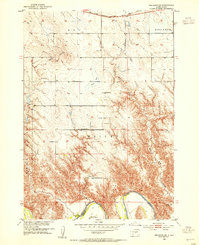
(67)- 1935 Map of Chamberlain, 1975 Print
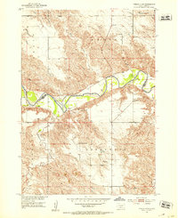
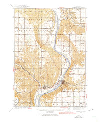 1935 Chamberlain1975 Print · USGSMid-century South Dakota river life centers on the Missouri crossing between Chamberlain and Oacoma during the mid-thirties. Genealogists can locate numerous country schools like Pleasant View Sch and historical sites such as the CCC Camp.
 - 1939 Map of Chamberlain
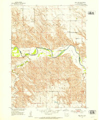
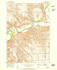
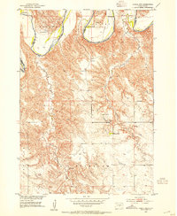
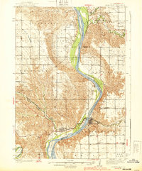 1939 Chamberlain1939 Print · USGSChamberlain and Oacoma face one another across the Missouri River in the late thirties, just as the region transitioned into the modern era. Genealogists and researchers can locate numerous country schools and churches, including St Albans Ch, Grace Mission Sch, and Riverview Cem.2 unique versions available
 - 1940 Map of Iona, 1958 Print
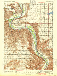
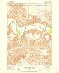
 1940 Iona1958 Print · USGSIn the early 1940s, the Missouri and White Rivers shaped life across South Dakota's Lyman and Brule counties. Genealogists can trace nearly twenty rural schoolhouses and cemeteries like Iona Cem, alongside landmarks such as Twilight Butte and the settlement of Iona.
 - 1944 Map of Iona
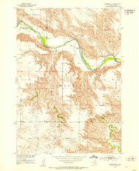
 1944 Iona1944 Print · USGSLyman County in the early 1940s reveals a landscape of isolated homesteads and river-bottom farms along the Missouri River. Genealogists and local historians can trace family roots through numerous country schools like Cable Sch and markers such as Iona Cem and Peterson.2 unique versions available
 - 1951 Map of Badnation, 1953 Print
 1951 Badnation1953 Print · USGSThe White River breaks of South Dakota are shown here in the early 1950s, revealing a landscape of remote settlements and mission churches. Researchers can locate the Bad Nation Indian Sch and rural congregations like St George Ch and St Catharine Ch.2 unique versions available
 - 1951 Map of Presho 4 NE, 1953 Print
 1951 Presho 4 NE1953 Print · USGSThe White River valley in the early fifties shows a remote landscape of prairie townships divided between Lyman and Tripp counties. Local historians can trace the foundations of rural life at sites like Holy Rosary Ch, North Greenwood Sch, and the winding Mission Creek.4 unique versions available
 - 1951 Map of Ideal NW, 1953 Print
 1951 Ideal NW1953 Print · USGSThe rural breaks of the White River valley are captured here in the early fifties during the development of the Missouri River Basin. Genealogists and local historians can trace family land near the Christensen Ranch or locate the Nelson Sch (Abandoned) and Edna Sch.2 unique versions available
 - 1951 Map of Ideal NE, 1953 Print
 1951 Ideal NE1953 Print · USGSThe White River meanders through the Lyman and Tripp county line during the early fifties, showing the rural structure of the Missouri River Basin. Genealogists can locate landmarks like Red Hill Ch, Red Hill Cem, and the Lone Star Sch among the breaks of the White River.2 unique versions available
 - 1951 Map of Presho 4 NW, 1953 Print
 1951 Presho 4 NW1953 Print · USGSThe White River breaks of South Dakota are captured in the early fifties during a period of Missouri River Basin development. Genealogists and local historians can trace isolated homesteads such as Krutson Ranch and Iverson Ranch or the location of the Pleasant Hill Sch.4 unique versions available
 - 1952 Map of Reliance SW, 1954 Print
 1952 Reliance SW1954 Print · USGSLyman County ranch lands meet the winding White River in the early fifties, showing a rural community defined by its remote schools and rugged terrain. Genealogists can locate family landmarks like the Nelson Ranch, Roosevelt Sch, and Trinity Cem.3 unique versions available
 - 1952 Map of Reliance SE, 1954 Print
 1952 Reliance SE1954 Print · USGSLyman County landscape in the early fifties shows the rural school system and river valleys before the Fort Randall Reservoir expansion. Genealogists can locate North Cooper Sch and West Cooper Sch, or trace the old Chicago Milwaukee St Paul and Pacific rail line.
 - 1952 Map of Hamill NW, 1954 Print
 1952 Hamill NW1954 Print · USGSThe ranchlands of Tripp and Lyman County are captured here in the early 1950s as the Missouri River Basin development program began. Researchers can trace historic family holdings like the Schooler Ranch or locate vanished rural schoolhouses such as Bellwood Sch and Gassman Sch.2 unique versions available
 - 1952 Map of Hamill NE, 1954 Print
 1952 Hamill NE1954 Print · USGSLyman County settlement along the White River is documented here in the early fifties, just as the regional landscape was being reshaped. Genealogists can locate family-named school sites like Lindgren Sch and Walcott Sch before the Missouri River Basin development.
 - 1952 Map of Oacoma, 1954 Print
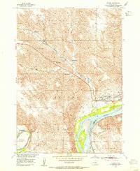 1952 Oacoma1954 Print · USGSLyman County ranching and river life are frozen in time just before the valley changed forever. Trace family roots at Oacoma Cem, locate the tracks of the Chicago Milwaukee St Paul and Pacific, or find the original sites of Sharp Ranch and Lindly Ranch.
 - 1952 Map of Iona NW, 1955 Print
 1952 Iona NW1955 Print · USGSThe Missouri River breaks across the Lyman and Brule county lines in the early fifties, just before the Fort Randall Reservoir began to reshape the valley. Genealogists can locate family holdings like Ellis Ranch or Krammer Ranch and trace the drainage of Bull Creek.2 unique versions available
 - 1953 Map of Huron, 1959 Print
 1953 Huron1959 Print · USGSCentral South Dakota comes alive in the mid-1950s as a thriving rail and agricultural corridor between the Missouri and James Rivers. Trace the legacy of family farms and prairie towns like Huron, Faulkton, and Wessington Springs along the historic Chicago and North Western rail lines.3 unique versions available
 - 1954 Map of Pierre, 1968 Print
 1954 Pierre1968 Print · USGSThe Missouri River and the newly formed Oahe Reservoir define central South Dakota in the 1950s. Genealogists and local historians can trace early settlements and rail stops like Eakin Siding, Mission Ridge, and Ottumwa.2 unique versions available
 - 1954 Map of Huron, 1977 Print
 1954 Huron1977 Print · USGSCentral South Dakota was a landscape of grain elevators and river bends during the mid-fifties. Genealogists and historians can trace the development of the James River valley through railroad towns like Redfield and the sprawling Crow Creek Indian Reservation.
 - 1955 Map of Martin, 1968 Print
 1955 Martin1968 Print · USGSTribal lands and rail corridors define the South Dakota plains in the mid-fifties, from the sand hills to the badlands. Genealogists and historians can trace the early layout of Pine Ridge Indian Reservation settlements and find small rail towns like Stamford and Witten.2 unique versions available
 - 1955 Map of Mitchell, 1973 Print
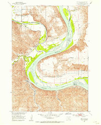
 1955 Mitchell1973 Print · USGSThe Missouri River valley undergoes a massive transformation in the mid-1950s as the Fort Randall Dam creates Lake Francis Case. You can trace the rail lines of the Chicago Milwaukee St Paul and Pacific through Mitchell or locate local landmarks like Butler Town Hall.2 unique versions available
 - 1958 Map of Pierre
 1958 Pierre1958 Print · USGSCentral South Dakota is documented during the mid-fifties, just as the Missouri River valley was being transformed by the massive Oahe Dam project. Researchers can trace the early Oahe Reservoir shoreline and find remote outposts like Milesville, Onida, and Giddings Flat.
 - 1958 Map of Martin
 1958 Martin1958 Print · USGSSouth Dakota's southern plains are documented here in the late fifties, showing the expansive Pine Ridge and Rosebud Indian Reservations. Genealogists and historians can locate early settlements along the Chicago Milwaukee St Paul and Pacific line or find family roots near Martin and the Indian Cemetery.
 - 1959 Map of Mitchell
 1959 Mitchell1959 Print · USGSSouth Dakota’s river and rail corridors come alive in the late fifties as the Missouri River valley undergoes dramatic change. Genealogists and historians can trace family roots through numerous small towns and schools such as Academy, Stickney, and Gregory.2 unique versions available
 - 1966 Map of Lower Brule NW, 1967 Print
 1966 Lower Brule NW1967 Print · USGSThe Missouri River valley in the mid-1960s shows a landscape transformed by the waters of Lake Sharpe. Researchers can locate rural landmarks like the Boot Bar Sch and Hidden Valley Sch alongside the West Bend Recreation Area.
 - 1966 Map of Joe Creek, 1967 Print
 1966 Joe Creek1967 Print · USGSThe Missouri River and the newly formed Lake Sharpe dominate the landscape in the mid-1960s, showing the intersection of tribal lands and new reservoirs. Genealogists and local historians can trace rural school locations like Riverdale Sch and Busy Bee Sch along the Joe Creek drainage.
Showing maps 1-25 of 67
Top cities of Lyman County
- Presho historical maps
- Oacoma historical maps
- Kennebec historical maps
- Reliance historical maps
- Iona historical maps
Frequently asked questions
- What are the different types of historical maps available for Lyman County?
- What is the oldest map of Lyman County?
- Where can I purchase historical maps of Lyman County for my home or office?
- Where can I download high-res historical maps of Lyman County?
- Are there historical topographic maps available for Lyman County?
- Is there historical aerial imagery available for Lyman County?
- Where are historical maps of Lyman County sourced from?