1960s Maps of Lyman County, South Dakota
Explore 14 historic maps of Lyman County from the 1960s. These maps offer a rare glimpse into what life looked like during the 1960s — showing old roads, neighborhoods, homes, and landmarks that have changed or disappeared over time.
Whether you're researching your family's past, planning a metal detecting trip, or studying how Lyman County's landscape evolved across the 1960s, these high-resolution maps are a powerful tool for exploring the history of this region.
- Focus on a specific era: All maps on this page are from the 1960s, giving you a focused view of this time period.
- See what’s changed: Compare century-old streets, trails, and buildings to today's modern landscape using overlays and satellite layers.
- Research with precision: Use these maps for genealogy, historical research, land use analysis, or educational projects.
- View, download, or print: Maps are fully viewable online in high resolution, and can be downloaded or printed for your own records.
Start exploring Lyman County's history through authentic maps from the 1960s. This is your window into the past.
Lyman County, SD maps
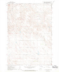
(14)- 1966 Map of Lower Brule NW, 1967 Print
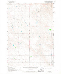
 1966 Lower Brule NW1967 Print · USGSThe Missouri River valley in the mid-1960s shows a landscape transformed by the waters of Lake Sharpe. Researchers can locate rural landmarks like the Boot Bar Sch and Hidden Valley Sch alongside the West Bend Recreation Area.
 - 1966 Map of Joe Creek, 1967 Print
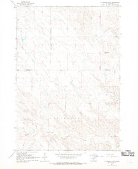
 1966 Joe Creek1967 Print · USGSThe Missouri River and the newly formed Lake Sharpe dominate the landscape in the mid-1960s, showing the intersection of tribal lands and new reservoirs. Genealogists and local historians can trace rural school locations like Riverdale Sch and Busy Bee Sch along the Joe Creek drainage.
 - 1966 Map of Big Bend Dam SE, 1967 Print
 1966 Big Bend Dam SE1967 Print · USGSBuffalo County during the mid-sixties shows a landscape shaped by the Missouri River Basin development. Researchers can trace the tribal boundaries of the Crow Creek Indian Reservation and locate landmarks like Lees Corner and Lake Francis Case.
 - 1966 Map of Ft. George Butte SE, 1967 Print
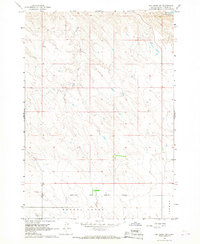
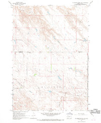
 1966 Ft. George Butte SE1967 Print · USGSThe Lyman County prairie comes to life in the mid-1960s, showing a landscape defined by reservation boundaries and isolated rural outposts. Genealogists and researchers can trace local landmarks like the Brule Sch, the Old Indian Treaty Boundary, and the waters of Grouse Creek.
 - 1966 Map of Joe Creek NW, 1967 Print
 1966 Joe Creek NW1967 Print · USGSThe Missouri River valley in the mid-1960s reveals a landscape transformed by the waters of Lake Sharpe along the reservation borders. Genealogists and historians can trace local landmarks like Holy Faith Cem, La Roche Sch, and the Clark Ranch.
 - 1966 Map of Big Bend Dam, 1967 Print
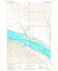 1966 Big Bend Dam1967 Print · USGSThe Missouri River landscape near the Crow Creek and Lower Brule reservations underwent dramatic changes in the mid-1960s following dam construction. Researchers can trace the layout of Fort Thompson, locate the St Joseph Cem, and identify old sites like the Big Bend Landing Strip.
 - 1966 Map of Lower Brule SW, 1967 Print
 1966 Lower Brule SW1967 Print · USGSLyman County, South Dakota is captured in the mid-sixties during the development of the Missouri River Basin. Genealogists and historians can trace local landmarks like Messiah Ch, Black Dog Sch, and the winding Medicine Creek.
 - 1966 Map of Joe Creek SE, 1967 Print
 1966 Joe Creek SE1967 Print · USGSLyman County ranchlands meet the rising waters of the Missouri River in the mid-sixties, just as the regional geography was being reshaped. Genealogists can trace the Lower Brule Indian Reservation Boundary and drainage basins like Bad Horse Creek and Dorman.
 - 1966 Map of Joe Creek SW, 1967 Print
 1966 Joe Creek SW1967 Print · USGSLyman County and the reservation lands are captured here in the mid-sixties, shortly after the Missouri River was transformed. Researchers can trace the Lower Brule Indian Reservation Boundary and the shoreline of Lake Sharpe.
 - 1966 Map of Lower Brule NE, 1967 Print
 1966 Lower Brule NE1967 Print · USGSThe Missouri River valley in the mid-sixties reveals a landscape reshaped by the rising waters of Missouri River Lake Sharpe. Local historians can trace the borders of the Lower Brule Indian Reservation Boundary and locate a small Cem near the bluffs.
 - 1966 Map of Lower Brule, 1967 Print
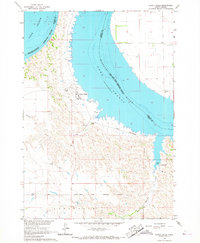 1966 Lower Brule1967 Print · USGSThe Missouri River breaks and the waters of Lake Sharpe define this mid-1960s look at the Lower Brule community. Researchers can locate the Council House, Christ Ch, and early recreation sites like the Counselor Creek Recreation Area.2 unique versions available
 - 1967 Map of Ft. George Butte NW, 1969 Print
 1967 Ft. George Butte NW1969 Print · USGSThe high plains of Lyman and Stanley Counties are shown here in the late sixties, a landscape of ranch lands and isolated rural outposts. Genealogists and local historians can locate the Cedar Valley Sch and trace the winding courses of Antelope Creek and Cedar Creek.
 - 1967 Map of Ft. George Butte SW, 1969 Print
 1967 Ft. George Butte SW1969 Print · USGSLyman County ranch land and historic borders are preserved here in the late sixties. Researchers can trace the Old Indian Treaty Boundary and locate early water infrastructure like Knudson Dam or the headwaters of Nail Creek.
 - 1967 Map of Ft. George Butte, 1969 Print
 1967 Ft. George Butte1969 Print · USGSLyman and Stanley counties are captured here in the late sixties, divided by the Lower Brule Indian Reservation Boundary. Researchers can trace old water sources and landforms like Ft George Butte, Apple Creek, and Cedar Creek.
End of results
Showing maps 1-14 of 14
Top cities of Lyman County
- Presho historical maps
- Oacoma historical maps
- Kennebec historical maps
- Reliance historical maps
- Iona historical maps
Frequently asked questions
- What are the different types of historical maps available for Lyman County?
- What is the oldest map of Lyman County?
- Where can I purchase historical maps of Lyman County for my home or office?
- Where can I download high-res historical maps of Lyman County?
- Are there historical topographic maps available for Lyman County?
- Is there historical aerial imagery available for Lyman County?
- Where are historical maps of Lyman County sourced from?