
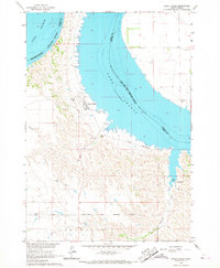
1966 Map of Lower Brule NW
USGS Topo · Published 1967About this map
Missouri River waters dominate this mid-1960s landscape, where the formation of Lake Sharpe has fundamentally altered the terrain. The map captures a transitional moment for the region as areas subject to controlled inundation are clearly delineated, reflecting the impact of the Big Bend Dam downstream. Along the western banks, the West Bend Recreation Area and a public Boat Ramp indicate the shift toward water-based recreation that followed the river's transformation. Further inland, the presence of the Boot Bar Sch and Hidden Valley Sch provides essential touchpoints for family historians and genealogists studying the rural education network of Hughes and Lyman Counties. The complex jurisdictional landscape is also meticulously noted, showing the meeting of the Crow Creek Indian Reservation and the Lower Brule Indian Reservation along the river's path.
Find a feature on this map
18 named features on this map. Tap any name to fly to it.
Don’t see what you’re looking for? This feature index may not catch every label — zoom into the map to look around manually.
Map Details
Editions of this 1966 Lower Brule NW Map
This is the sole edition of this map. No revisions or reprints were ever made.
Other maps of this area

1953 · Huron
USGS Topo · 1:250,000

1954 · Huron
USGS Topo · 1:250,000

1966 · Joe Creek
USGS Topo · 1:24,000

1966 · Lower Brule SW
USGS Topo · 1:24,000

1966 · Joe Creek SE
USGS Topo · 1:24,000

1966 · Lower Brule NE
USGS Topo · 1:24,000
1966 · Lower Brule
USGS Topo · 1:24,000
1973 · Chapelle Lake SE
USGS Topo · 1:24,000
1973 · De Grey SE
USGS Topo · 1:24,000

1973 · Chapelle Lake SW
USGS Topo · 1:24,000