
1966 Map of Lower Brule
USGS Topo · Published 1967About this map
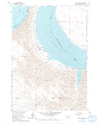
Lower Brule sits on the western banks of Lake Sharpe, a massive reservoir created by the damming of the Missouri River. Mapped in the mid-1960s, this area is the heart of the Lower Brule Indian Reservation, showing the community's layout including the Council House, a local Cem, and a distinctive Water Tank. The landscape is defined by the sharp contrast between the deeply eroded breaks of the western shoreline and the broad, blue expanse of the water, which also serves as the boundary with the Crow Creek Indian Reservation to the east.
Find a feature on this map
20 named features on this map. Tap any name to fly to it.
Don’t see what you’re looking for? This feature index may not catch every label — zoom into the map to look around manually.
Map Details
Editions of this 1966 Lower Brule Map
2 editions found
Other maps of this area

1935 · Chamberlain
USGS Topo · 1:62,500

1939 · Chamberlain
USGS Topo · 1:62,500

1953 · Huron
USGS Topo · 1:250,000

1954 · Huron
USGS Topo · 1:250,000

1955 · Mitchell
USGS Topo · 1:250,000

1959 · Mitchell
USGS Topo · 1:250,000

1966 · Lower Brule NW
USGS Topo · 1:24,000

1966 · Stephan
USGS Topo · 1:24,000

1966 · Big Bend Dam
USGS Topo · 1:24,000

1966 · Lower Brule SW
USGS Topo · 1:24,000
Featured Places
- Fort Thompson District, SD
- Grey Hill West Township, Fort Thompson District
- Victory West Township, Fort Thompson District
- Big Bend District, SD
- Lower Brule, SD