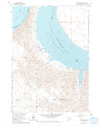
1966 Map of Lower Brule
USGS Topo · Published 1967About this map
Lower Brule sits on the western bank of the Missouri River within the Lower Brule Indian Reservation, just as the landscape was being reshaped by the Missouri River Basin development program. The newly formed Lake Sharpe dominates the center of the map, its waters covering the old river channel and creating new shorelines along the Lyman and Buffalo County line. The community center of Lower Brule is clearly visible, featuring the Council House, a Cem, and a Water Tank that served the local population during this mid-1960s era.
Find a feature on this map
20 named features on this map. Tap any name to fly to it.
Don’t see what you’re looking for? This feature index may not catch every label — zoom into the map to look around manually.
Map Details
Editions of this 1966 Lower Brule Map
2 editions found

Other maps of this area

1935 · Chamberlain
USGS Topo · 1:62,500

1939 · Chamberlain
USGS Topo · 1:62,500

1953 · Huron
USGS Topo · 1:250,000

1954 · Huron
USGS Topo · 1:250,000

1955 · Mitchell
USGS Topo · 1:250,000

1959 · Mitchell
USGS Topo · 1:250,000

1966 · Lower Brule NW
USGS Topo · 1:24,000

1966 · Stephan
USGS Topo · 1:24,000

1966 · Big Bend Dam
USGS Topo · 1:24,000

1966 · Lower Brule SW
USGS Topo · 1:24,000
Featured Places
- Victory West Township, Fort Thompson District
- Grey Hill West Township, Fort Thompson District
- Big Bend District, SD
- Council House, SD
- Fort Thompson District, SD