1980s Maps of Wood, South Dakota
Explore 4 historic maps of Wood from the 1980s. These maps offer a rare glimpse into what life looked like during the 1980s — showing old roads, neighborhoods, homes, and landmarks that have changed or disappeared over time.
Whether you're researching your family's past, planning a metal detecting trip, or studying how Wood's landscape evolved across the 1980s, these high-resolution maps are a powerful tool for exploring the history of this region.
- Focus on a specific era: All maps on this page are from the 1980s, giving you a focused view of this time period.
- See what’s changed: Compare century-old streets, trails, and buildings to today's modern landscape using overlays and satellite layers.
- Research with precision: Use these maps for genealogy, historical research, land use analysis, or educational projects.
- View, download, or print: Maps are fully viewable online in high resolution, and can be downloaded or printed for your own records.
Start exploring Wood's history through authentic maps from the 1980s. This is your window into the past.
Wood, SD maps
(4)- 1982 Map of Wood North
 1982 Wood North1982 Print · USGSMellette County during the early eighties remains a landscape defined by its natural waterways and tribal boundaries. Genealogists and researchers can trace the winding courses of White Thunder Creek and Butte Creek through the Rosebud and Cody areas.
 - 1982 Map of Wood South
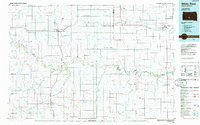
 1982 Wood South1982 Print · USGSThe northern edge of the Rosebud Reservation comes into focus during the early 1980s, centered on the community of Wood. Researchers can trace local landmarks and burial sites like the Grandstand Rodeo Arena, Evergreen Cem, and Rattlesnake Butte.
 - 1982 Map of Mission, 1983 Print
 1982 Mission1983 Print · USGSThe Rosebud Reservation in the early eighties shows a landscape of plains communities and aviation outposts. Genealogists and researchers can trace local centers like Mission, Rosebud, and St Francis, or locate family landmarks near Antelope Lake and the Keya Paha River.
 - 1985 Map of White River, 1986 Print
 1985 White River1986 Print · USGSSouth-central South Dakota comes into focus during the mid-eighties as a critical junction of rail and river life. Researchers can trace the Chicago and North Western line through high-plains towns like Murdo and Presho or locate rural landmarks such as Stony Butte and Fate Dam.2 unique versions available
End of results
Showing maps 1-4 of 4
Top cities near Wood
Frequently asked questions
- What are the different types of historical maps available for Wood?
- What is the oldest map of Wood?
- Where can I purchase historical maps of Wood for my home or office?
- Where can I download high-res historical maps of Wood?
- Are there historical topographic maps available for Wood?
- Is there historical aerial imagery available for Wood?
- Where are historical maps of Wood sourced from?