1960s Maps of Enterprise Township, South Dakota
Explore 4 historic maps of Enterprise Township from the 1960s. These maps offer a rare glimpse into what life looked like during the 1960s — showing old roads, neighborhoods, homes, and landmarks that have changed or disappeared over time.
Whether you're researching your family's past, planning a metal detecting trip, or studying how Enterprise Township's landscape evolved across the 1960s, these high-resolution maps are a powerful tool for exploring the history of this region.
- Focus on a specific era: All maps on this page are from the 1960s, giving you a focused view of this time period.
- See what’s changed: Compare century-old streets, trails, and buildings to today's modern landscape using overlays and satellite layers.
- Research with precision: Use these maps for genealogy, historical research, land use analysis, or educational projects.
- View, download, or print: Maps are fully viewable online in high resolution, and can be downloaded or printed for your own records.
Start exploring Enterprise Township's history through authentic maps from the 1960s. This is your window into the past.
Enterprise Township, SD maps
(4)- 1962 Map of Colton SE, 1963 Print
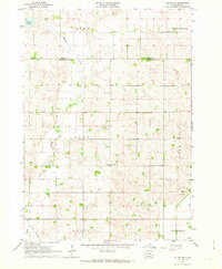 1962 Colton SE1963 Print · USGSMinnehaha County's rural townships are captured in the early sixties as they balanced traditional agriculture with evolving transport. Trace local genealogy and infrastructure through the Willow Creek Ch, Burk Cem, and an Old Railroad Grade.2 unique versions available
 - 1962 Map of Dell Rapids, 1963 Print
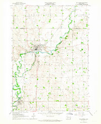 1962 Dell Rapids1963 Print · USGSDell Rapids and the Big Sioux River valley are captured in the early sixties, showing a landscape shaped by water and rail. Trace family roots at Nelson Cem and St Olaf Cem, or locate the rural Carothers Sch No 86 and the local Quarry.2 unique versions available
 - 1963 Map of Trent, 1964 Print
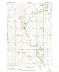 1963 Trent1964 Print · USGSMoody County's rail and river landscape is captured here in the early sixties as the Big Sioux valley remained a vital transport corridor. Genealogists can trace family footprints at Gale Ridge Sch and several local burial grounds like Hillside Cem and Trent Cem.2 unique versions available
 - 1963 Map of Colman, 1964 Print
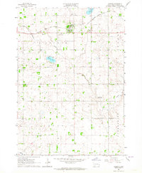 1963 Colman1964 Print · USGSThe prairie landscape of Moody County comes into focus in the early sixties, centered on the rail-linked town of Colman. Genealogists can trace rural family roots through several local landmarks like Devaney Sch, West Ch, and Molskness Cem.3 unique versions available
End of results
Showing maps 1-4 of 4
Top cities near Enterprise Township
- Dell Rapids historical maps
- Flandreau historical maps
- Crooks historical maps
- Baltic historical maps
- Garretson historical maps
- Lyons historical maps
See more
Top neighborhoods of Enterprise Township
Frequently asked questions
- What are the different types of historical maps available for Enterprise Township?
- What is the oldest map of Enterprise Township?
- Where can I purchase historical maps of Enterprise Township for my home or office?
- Where can I download high-res historical maps of Enterprise Township?
- Are there historical topographic maps available for Enterprise Township?
- Is there historical aerial imagery available for Enterprise Township?
- Where are historical maps of Enterprise Township sourced from?