1900s (20th Century) Maps of Five Points, South Dakota
Explore 6 historic maps of Five Points from the 1900s (20th Century). These maps offer a rare glimpse into what life looked like during the 1900s — showing old roads, neighborhoods, homes, and landmarks that have changed or disappeared over time.
Whether you're researching your family's past, planning a metal detecting trip, or studying how Five Points's landscape evolved across the 1900s, these high-resolution maps are a powerful tool for exploring the history of this region.
- Focus on a specific era: All maps on this page are from the 1900s, giving you a focused view of this time period.
- See what’s changed: Compare century-old streets, trails, and buildings to today's modern landscape using overlays and satellite layers.
- Research with precision: Use these maps for genealogy, historical research, land use analysis, or educational projects.
- View, download, or print: Maps are fully viewable online in high resolution, and can be downloaded or printed for your own records.
Start exploring Five Points's history through authentic maps from the 1900s. This is your window into the past.
Five Points, SD maps
(6)- 1901 Map of Harney Peak
 1901 Harney Peak1901 Print · USGSThe Black Hills at the dawn of the twentieth century was a hub of hard-rock mining and frontier ranching. Genealogists and historians can trace dozens of family-named homesteads like Hawks Ranch alongside significant early mines such as the Storm Hill Mine and Grizzly Bear Mine.4 unique versions available
 - 1954 Map of Hill City, 1955 Print
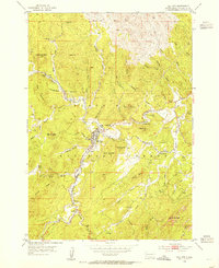 1954 Hill City1955 Print · USGSHill City and the surrounding Black Hills were centers of intense mineral exploration during the mid-fifties. Genealogists and historians can trace the old rail lines of the Chicago Burlington and Quincy and locate specific sites like the Hidden Treasure Mine, Canadaville, and the Reder Ranger Station.5 unique versions available
 - 1955 Map of Hot Springs, 1958 Print
 1955 Hot Springs1958 Print · USGSThe Black Hills and South Dakota badlands are captured here in the mid-fifties, during a peak of military and industrial activity. Researchers can locate the Black Hills Ordnance Depot, early Uranium Mines, and historic rail stops like Pringle or Oglala.5 unique versions available
 - 1956 Map of Custer
 1956 Custer1956 Print · USGSThe Black Hills region around Custer and Hill City appears here during the mid-fifties, showing a landscape defined by timber, tourism, and hard-rock mining. You can locate family-named landmarks and remote sites like the Crazy Horse Carving, South Slate Sch, and the Western Star Mine.2 unique versions available
 - 1977 Map of Mount Rushmore, 1978 Print
 1977 Mount Rushmore1978 Print · USGSThe Black Hills landscape of the late 1970s is shown here at a moment when historic mining and modern tourism converged. Genealogists and researchers can trace the rail lines of the Burlington Northern and find sites like Spokane Mine or the town of Pringle.2 unique versions available
 - 1998 Map of Hill City, 2001 Print
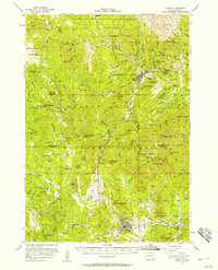
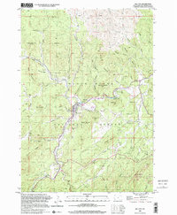 1998 Hill City2001 Print · USGSHill City and the surrounding Black Hills peaks appear here during the late 1990s, revealing a landscape defined by deep mining roots. Local researchers can trace dozens of named prospects and workings, including the Hidden Treasure Mine, Sunnyside Mine, and the small settlement of Kennedyville.
End of results
Showing maps 1-6 of 6
Top cities near Five Points
- Rapid City historical maps
- Summerset historical maps
- Custer historical maps
- Hill City historical maps
- Keystone historical maps
Frequently asked questions
- What are the different types of historical maps available for Five Points?
- What is the oldest map of Five Points?
- Where can I purchase historical maps of Five Points for my home or office?
- Where can I download high-res historical maps of Five Points?
- Are there historical topographic maps available for Five Points?
- Is there historical aerial imagery available for Five Points?
- Where are historical maps of Five Points sourced from?