Old Maps of Rockerville, South Dakota for Academic Research
Study the evolution of Rockerville with 10 high-resolution historic maps. Whether you're teaching, researching, or modeling changes in land use, these maps provide essential visual documentation of urban, environmental, and geographic change.
- Analyze long-term change: Track patterns in development, transportation, and natural features.
- Ideal for environmental or urban studies: Support academic projects with primary historical map data.
- Use in the classroom or lab: Educators and researchers rely on these maps to bring historical context to life.
These maps are a powerful tool for teaching, research, and visualizing how Rockerville has changed over the decades.
Rockerville, SD maps
(10)- 1894 Map of Hermosa
 1894 Hermosa1894 Print · USGSThe Black Hills gold and ranching frontier comes into focus during the late nineteenth century as mining camps and rail lines began to anchor the territory. Genealogists and historians can trace early families in Keystone, Rockerville, and around the Etta Mine.2 unique versions available
 - 1901 Map of Hermosa
 1901 Hermosa1901 Print · USGSThe Black Hills frontier comes alive in this survey of Pennington and Custer counties during the height of the regional mining boom. Researchers can trace the early footprints of Keystone, Rockerville, and Wind Cave, along with vanished industrial sites like Etta Mill.4 unique versions available
 - 1954 Map of Rockerville, 1955 Print
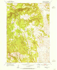 1954 Rockerville1955 Print · USGSPennington County’s mining and rural school landscape is captured here in the mid-1950s. Genealogists and historians can trace the foundations of the community through the Rockerville Cem, local mines like the Giltedge Mine, and landmarks like Crystal Cave.3 unique versions available
 - 1954 Map of Mount Rushmore, 1958 Print
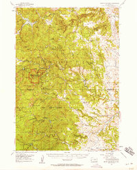 1954 Mount Rushmore1958 Print · USGSThe Black Hills in the mid-fifties reveal a rugged landscape defined by both mining history and national monuments. Researchers can trace the legacy of the Gold Rush through sites like Etta Mine, Spokane, and the Boulder Hill Lookout Tower.3 unique versions available
 - 1955 Map of Hot Springs, 1958 Print
 1955 Hot Springs1958 Print · USGSThe Black Hills and South Dakota badlands are captured here in the mid-fifties, during a peak of military and industrial activity. Researchers can locate the Black Hills Ordnance Depot, early Uranium Mines, and historic rail stops like Pringle or Oglala.5 unique versions available
 - 1977 Map of Mount Rushmore, 1978 Print
 1977 Mount Rushmore1978 Print · USGSThe Black Hills landscape of the late 1970s is shown here at a moment when historic mining and modern tourism converged. Genealogists and researchers can trace the rail lines of the Burlington Northern and find sites like Spokane Mine or the town of Pringle.2 unique versions available
 - 2012 Map of Rockerville, 2012 Print
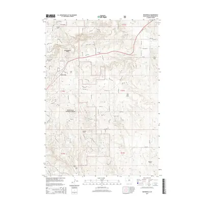
 2012 Rockerville2012 Print · USGSCovers Rockerville, including Pennington County, United States, and other nearby areas
 - 2015 Map of Rockerville, 2015 Print
 2015 Rockerville2015 Print · USGSCovers Rockerville, including Pennington County, United States, and other nearby areas
 - 2017 Map of Rockerville, 2017 Print
 2017 Rockerville2017 Print · USGSCovers Rockerville, including Pennington County, United States, and other nearby areas
 - 2021 Map of Rockerville, 2021 Print
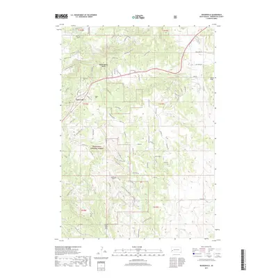
 2021 Rockerville2021 Print · USGSPennington County’s high-country mining and forest lands are shown here as they appear in the early 2020s. Researchers can trace historic site names and family burials at Rockerville Cem, Taylor Quarry, and the Deadman Placer claims.
End of results
Showing maps 1-10 of 10
Top cities near Rockerville
- Rapid City historical maps
- Box Elder historical maps
- Summerset historical maps
- Custer historical maps
- Hill City historical maps
- Hermosa historical maps
See more
Frequently asked questions
- What are the different types of historical maps available for Rockerville?
- What is the oldest map of Rockerville?
- Where can I purchase historical maps of Rockerville for my home or office?
- Where can I download high-res historical maps of Rockerville?
- Are there historical topographic maps available for Rockerville?
- Is there historical aerial imagery available for Rockerville?
- Where are historical maps of Rockerville sourced from?