1960s Maps of Spink County, South Dakota
Explore 14 historic maps of Spink County from the 1960s. These maps offer a rare glimpse into what life looked like during the 1960s — showing old roads, neighborhoods, homes, and landmarks that have changed or disappeared over time.
Whether you're researching your family's past, planning a metal detecting trip, or studying how Spink County's landscape evolved across the 1960s, these high-resolution maps are a powerful tool for exploring the history of this region.
- Focus on a specific era: All maps on this page are from the 1960s, giving you a focused view of this time period.
- See what’s changed: Compare century-old streets, trails, and buildings to today's modern landscape using overlays and satellite layers.
- Research with precision: Use these maps for genealogy, historical research, land use analysis, or educational projects.
- View, download, or print: Maps are fully viewable online in high resolution, and can be downloaded or printed for your own records.
Start exploring Spink County's history through authentic maps from the 1960s. This is your window into the past.
Spink County, SD maps
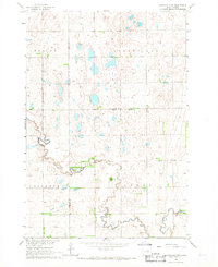
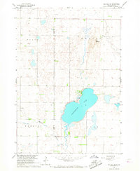
(14)- 1960 Map of Conde SW, 1961 Print
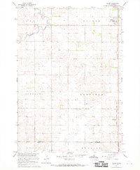
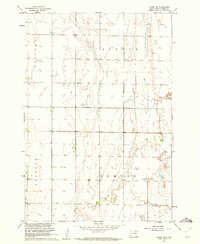 1960 Conde SW1961 Print · USGSSpink County’s rural townships are captured here in the early sixties as the Missouri River Basin development era shaped the plains. Researchers can locate the local Townhall, several Flowing Well sites, and the meandering path of Timber Creek.
 - 1960 Map of Brentford SE, 1961 Print
 1960 Brentford SE1961 Print · USGSSpink County, South Dakota, is captured here in the early sixties as the Missouri River Basin development program shaped the rural landscape. Genealogists and local historians can trace family roots at Baldwin Cem, locate the local Townhall, and follow the winding path of Dry Run.
 - 1960 Map of Northville, 1961 Print
 1960 Northville1961 Print · USGSThe Spink County prairie in the early sixties was defined by rail-centered trade and vast section-line farmsteads. Researchers can trace the Chicago and North Western line through Northville and Mellette, or locate family sites near Fairview Cem.
 - 1960 Map of Turton, 1962 Print
 1960 Turton1962 Print · USGSThe Spink County prairie comes into focus during the early sixties, centered on the rail-side settlement of Turton. Genealogists and researchers can trace the old Chicago and North Western line and locate local landmarks like the Flowing Well.2 unique versions available
 - 1960 Map of Athol, 1962 Print
 1960 Athol1962 Print · USGSSpink County agriculture and rail life are centered here in the early sixties, as the prairie landscape borders the winding Snake Creek. Genealogists and local historians can trace the Chicago and North Western rail line and locate St Marys Cem and the settlement of Athol.
 - 1966 Map of Northville SW, 1967 Print
 1966 Northville SW1967 Print · USGSThe prairie landscape along the border of Spink and Faulk counties is captured here in the mid-1960s. Researchers can locate the Grange Hall, trace the meanders of South Fork Snake Creek, and identify small-scale industrial Gravel Pits in the Athol and Wesley districts.
 - 1966 Map of Chelsea, 1967 Print
 1966 Chelsea1967 Print · USGSThe prairie landscape at the borders of Faulk and Spink counties is documented here in the mid-1960s. Genealogists and researchers can locate the Chelsea settlement, several Cem sites, and the path of an Old Railroad Grade.
 - 1966 Map of Redfield South, 1967 Print
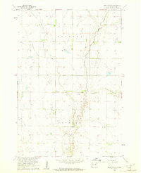
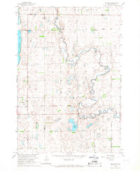
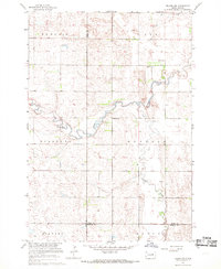
 1966 Redfield South1967 Print · USGSSpink County's agricultural and rail landscape is captured here in the mid-sixties, centered on the growing hub of Redfield. Researchers can trace the dual rail lines of the Chicago and North Western and C M St P & P near the waters of Twin Lakes.
 - 1966 Map of Zell, 1967 Print
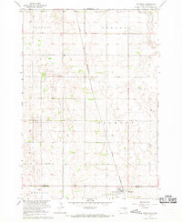
 1966 Zell1967 Print · USGSCentral South Dakota prairie life is captured here in the mid-sixties, where the borders of Faulk, Spink, and Hand counties meet. Trace the rail corridor of the Chicago and North Western through Zell or locate the Mountain Sch.
 - 1966 Map of Redfield SW, 1967 Print
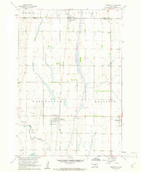
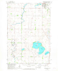
 1966 Redfield SW1967 Print · USGSThe prairie landscape of the Hand and Spink county line is captured in the mid-1960s, showing a region defined by its water and game management. Genealogists and historians can trace the borders of the State Game Refuge and locate Cottonwood Lake and the Cem to its north.
 - 1967 Map of Frankfort SW, 1968 Print
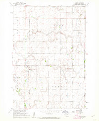
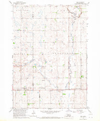
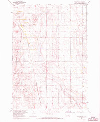 1967 Frankfort SW1968 Print · USGSSpink County during the late sixties reveals an intricate grid of farmsteads and railroads essential to the South Dakota prairie economy. Researchers can locate the Crandon Cem, trace the path of the Chicago and North Western railroad, and identify early Townhall sites.
 - 1967 Map of Tulare NW, 1968 Print
 1967 Tulare NW1968 Print · USGSSpink and Hand counties are captured in the mid-1960s, showing a prairie landscape defined by meandering creek beds and rural townships. Researchers can trace local history through landmarks like St Johns Ch, Buffalo Cem, and a notable Flowing Well.
 - 1967 Map of Hitchcock, 1969 Print
 1967 Hitchcock1969 Print · USGSThe rural prairie of Beadle and Spink counties comes into focus during the late 1960s, centered on the railroad town of Hitchcock. Researchers can trace the CHICAGO AND NORTH WESTERN line and locate rural landmarks like Tulare Cem and Flowing Well.
 - 1967 Map of Tulare, 1970 Print
 1967 Tulare1970 Print · USGSThe Spink County prairie near Tulare is captured in the late sixties, showing a landscape defined by the Milwaukee Road railroad. Researchers can locate the Garfield Cem, the remote siding at Spottswood, and the many agricultural wells that sustained these townships.
End of results
Showing maps 1-14 of 14
Top cities of Spink County
Frequently asked questions
- What are the different types of historical maps available for Spink County?
- What is the oldest map of Spink County?
- Where can I purchase historical maps of Spink County for my home or office?
- Where can I download high-res historical maps of Spink County?
- Are there historical topographic maps available for Spink County?
- Is there historical aerial imagery available for Spink County?
- Where are historical maps of Spink County sourced from?