1960s Maps of Turner County, South Dakota
Explore 11 historic maps of Turner County from the 1960s. These maps offer a rare glimpse into what life looked like during the 1960s — showing old roads, neighborhoods, homes, and landmarks that have changed or disappeared over time.
Whether you're researching your family's past, planning a metal detecting trip, or studying how Turner County's landscape evolved across the 1960s, these high-resolution maps are a powerful tool for exploring the history of this region.
- Focus on a specific era: All maps on this page are from the 1960s, giving you a focused view of this time period.
- See what’s changed: Compare century-old streets, trails, and buildings to today's modern landscape using overlays and satellite layers.
- Research with precision: Use these maps for genealogy, historical research, land use analysis, or educational projects.
- View, download, or print: Maps are fully viewable online in high resolution, and can be downloaded or printed for your own records.
Start exploring Turner County's history through authentic maps from the 1960s. This is your window into the past.
Turner County, SD maps
(11)- 1962 Map of Hartford South, 1964 Print
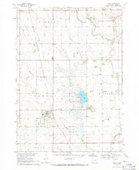
 1962 Hartford South1964 Print · USGSMinnehaha County in the early sixties shows a rural landscape on the cusp of change as the interstate highway system reaches the prairie. Researchers can trace dozens of family-named landmarks and country schools like Muchow Sch, Sunshine Sch, and Lakeview Sch.2 unique versions available
 - 1962 Map of Lennox NW, 1964 Print
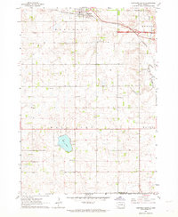
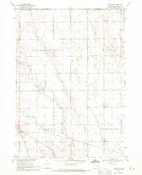
 1962 Lennox NW1964 Print · USGSThe rural landscape of Turner County comes into focus in the early sixties, showing a region of dense family farms and township schools. Researchers can locate many local landmarks, from the Norwegian Cem and Chancellor Cem to the tracks of the Great Northern railroad.2 unique versions available
 - 1964 Map of Lennox, 1966 Print
 1964 Lennox1966 Print · USGSThe rural prairie of Lincoln and Turner Counties comes alive in the 1960s, showing a well-established network of rail towns and country school districts. Researchers can trace family roots through sites like Delaware Ch, Lennox Cem, and several schoolhouses including Sunny Side Sch.
 - 1968 Map of Beresford NW, 1971 Print
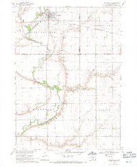
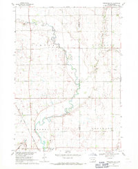 1968 Beresford NW1971 Print · USGSSoutheast South Dakota's farm country comes alive in the late sixties, centered on the river valley and rail corridor near Centerville. Genealogists and historians can trace rural roots through landmarks like Mt Zion Cem, Ash Grove Sch, and the winding Vermillion River.
 - 1968 Map of Parker NE, 1971 Print
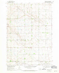
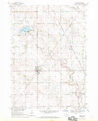
 1968 Parker NE1971 Print · USGSTurner County farm country and the river forks near Parker are captured here in the late sixties. Genealogists can locate family landmarks like Wellington Cem or rural schoolhouses including Stanford Sch and Sletten Sch.
 - 1968 Map of Hurley, 1971 Print
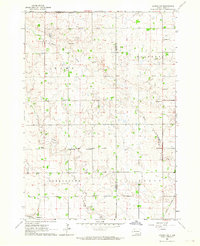
 1968 Hurley1971 Print · USGSTurner County at the end of the sixties reveals a landscape of railroad towns and prairie rivers. Genealogists and local historians can trace family roots near Hurley, locate the Stoddard Sch, or follow the Chicago and North Western rail line.
 - 1968 Map of Parker SW, 1971 Print
 1968 Parker SW1971 Print · USGSTurner County's agricultural heartland is documented in the late sixties, showing a landscape of established farmsteads and rural townships. Researchers can locate vanished landmarks like Dedrick Sch, Zion Cem, and the waters of Swan Lake.
 - 1968 Map of Wakonda, 1971 Print
 1968 Wakonda1971 Print · USGSDakota farmland near Wakonda comes into focus during the late sixties, revealing the organized grid of townships and rural waterways. Genealogists and historians can trace family locations near Columkill Cem, Holland Cem, and the quiet crossroads of Colfax Corner.
 - 1968 Map of Centerville, 1971 Print
 1968 Centerville1971 Print · USGSCenterville was a bustling agricultural hub in the late sixties, where the railroad and the Vermillion River intersect. Genealogists can trace family roots through the rural townships to find Ivey Sch, Komstad Ch, and Hovde Cem.
 - 1968 Map of Viborg, 1971 Print
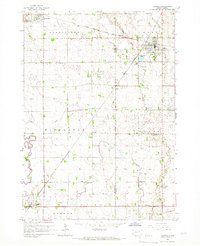
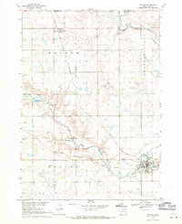
 1968 Viborg1971 Print · USGSSoutheast South Dakota's farm country comes into focus in the late 1960s, showing a landscape shaped by rail lines and prairie drainages. Genealogists can trace family roots through sites like Hattervig Cem, Rosefield Sch, and the rail junction at Viborg.
 - 1968 Map of Parker, 1971 Print
 1968 Parker1971 Print · USGSParker and Monroe are captured in the late sixties at the convergence of two major rail lines and the forks of the Vermillion River. Researchers can locate the Thunder Valley Drag Strip, the Parker Valley Country Club, and several local cemeteries like Rose Hill Cem.
End of results
Showing maps 1-11 of 11
Top cities of Turner County
Frequently asked questions
- What are the different types of historical maps available for Turner County?
- What is the oldest map of Turner County?
- Where can I purchase historical maps of Turner County for my home or office?
- Where can I download high-res historical maps of Turner County?
- Are there historical topographic maps available for Turner County?
- Is there historical aerial imagery available for Turner County?
- Where are historical maps of Turner County sourced from?