1970s Maps of Java, South Dakota
Explore 3 historic maps of Java from the 1970s. These maps offer a rare glimpse into what life looked like during the 1970s — showing old roads, neighborhoods, homes, and landmarks that have changed or disappeared over time.
Whether you're researching your family's past, planning a metal detecting trip, or studying how Java's landscape evolved across the 1970s, these high-resolution maps are a powerful tool for exploring the history of this region.
- Focus on a specific era: All maps on this page are from the 1970s, giving you a focused view of this time period.
- See what’s changed: Compare century-old streets, trails, and buildings to today's modern landscape using overlays and satellite layers.
- Research with precision: Use these maps for genealogy, historical research, land use analysis, or educational projects.
- View, download, or print: Maps are fully viewable online in high resolution, and can be downloaded or printed for your own records.
Start exploring Java's history through authentic maps from the 1970s. This is your window into the past.
Java, SD maps
(3)- 1974 Map of Lowry NW, 1978 Print
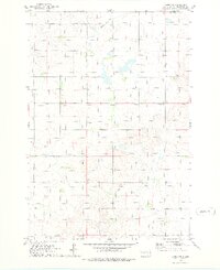 1974 Lowry NW1978 Print · USGSThe northern plains of Walworth County come into focus in the mid-1970s, showcasing a rural landscape defined by grain and rail. Genealogists and historians can locate the Java Sch, the village Java, and the path of the Old Railroad Grade.
 - 1978 Map of Java SE, 1979 Print
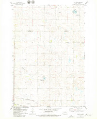 1978 Java SE1979 Print · USGSThe open prairie of the Dakotas is captured in the late seventies, showing a landscape shaped by rural faith and rail transit. Genealogists and local historians can locate several family burial grounds like Baptist Cem and trace the path of the Chicago Milwaukee St Paul and Pacific railroad.
 - 1978 Map of Java, 1979 Print
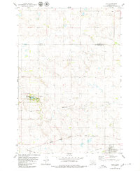 1978 Java1979 Print · USGSThe town of Java and the surrounding plains of Walworth County appear here in the late seventies. Family historians can trace local roots through several burial grounds like Peace Cem and Schnaible Cem or follow the Chicago Milwaukee St Paul and Pacific rail line.
End of results
Showing maps 1-3 of 3
Top cities near Java
Frequently asked questions
- What are the different types of historical maps available for Java?
- What is the oldest map of Java?
- Where can I purchase historical maps of Java for my home or office?
- Where can I download high-res historical maps of Java?
- Are there historical topographic maps available for Java?
- Is there historical aerial imagery available for Java?
- Where are historical maps of Java sourced from?