1970s Maps of Ziebach County, South Dakota
Explore 3 historic maps of Ziebach County from the 1970s. These maps offer a rare glimpse into what life looked like during the 1970s — showing old roads, neighborhoods, homes, and landmarks that have changed or disappeared over time.
Whether you're researching your family's past, planning a metal detecting trip, or studying how Ziebach County's landscape evolved across the 1970s, these high-resolution maps are a powerful tool for exploring the history of this region.
- Focus on a specific era: All maps on this page are from the 1970s, giving you a focused view of this time period.
- See what’s changed: Compare century-old streets, trails, and buildings to today's modern landscape using overlays and satellite layers.
- Research with precision: Use these maps for genealogy, historical research, land use analysis, or educational projects.
- View, download, or print: Maps are fully viewable online in high resolution, and can be downloaded or printed for your own records.
Start exploring Ziebach County's history through authentic maps from the 1970s. This is your window into the past.
Ziebach County, SD maps
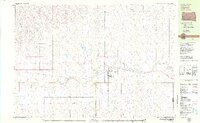
(3)- 1978 Map of Isabel SW, 1979 Print
 1978 Isabel SW1979 Print · USGSThe Cheyenne River Indian Reservation interior is shown here in the late seventies as a landscape of remote prairie and winding waterways. Researchers can trace the path of Red Earth Creek across the county line or locate the secluded Jewitt Pond.
 - 1978 Map of Isabel, 1979 Print
 1978 Isabel1979 Print · USGSIn the late 1970s, the community of Isabel was a vital cross-section of South Dakota rail and reservation life. Trace the path of the Chicago Milwaukee St Paul and Pacific railroad or locate family roots at Hillview Cem.
 - 1979 Map of Dupree
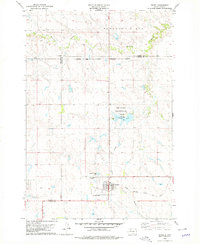
 1979 Dupree1979 Print · USGSThe Ziebach County seat of Dupree is captured in the late seventies as a vital rail and aviation hub on the South Dakota plains. Researchers can trace the Milwaukee Road rail line and locate local landmarks like Bedners Dam and the Dupree Municipal Airport.
End of results
Showing maps 1-3 of 3
Frequently asked questions
- What are the different types of historical maps available for Ziebach County?
- What is the oldest map of Ziebach County?
- Where can I purchase historical maps of Ziebach County for my home or office?
- Where can I download high-res historical maps of Ziebach County?
- Are there historical topographic maps available for Ziebach County?
- Is there historical aerial imagery available for Ziebach County?
- Where are historical maps of Ziebach County sourced from?