1980s Maps of Ziebach County, South Dakota
Explore 37 historic maps of Ziebach County from the 1980s. These maps offer a rare glimpse into what life looked like during the 1980s — showing old roads, neighborhoods, homes, and landmarks that have changed or disappeared over time.
Whether you're researching your family's past, planning a metal detecting trip, or studying how Ziebach County's landscape evolved across the 1980s, these high-resolution maps are a powerful tool for exploring the history of this region.
- Focus on a specific era: All maps on this page are from the 1980s, giving you a focused view of this time period.
- See what’s changed: Compare century-old streets, trails, and buildings to today's modern landscape using overlays and satellite layers.
- Research with precision: Use these maps for genealogy, historical research, land use analysis, or educational projects.
- View, download, or print: Maps are fully viewable online in high resolution, and can be downloaded or printed for your own records.
Start exploring Ziebach County's history through authentic maps from the 1980s. This is your window into the past.
Ziebach County, SD maps
(37)- 1981 Map of Herbert Creek
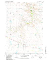
 1981 Herbert Creek1981 Print · USGSThe ranch lands of Ziebach County are captured here in the early eighties, showing a sparse landscape of family operations and vital water infrastructure. Genealogists and local historians can trace legacy holdings like the Webb Ranch and Skates Ranch or locate Shupic Park in Eagle Butte.
 - 1981 Map of Herbert Creek SW
 1981 Herbert Creek SW1981 Print · USGSThe high plains of Ziebach and Dewey counties are shown here in the early eighties as the waters of the Cheyenne River met the Oahe reservoir. Genealogists can trace family-named homesteads such as the Kessler Ranch, Pearman Ranch, and Zorc Ranch across the prairie.
 - 1981 Map of Lantry, 1982 Print
 1981 Lantry1982 Print · USGSThe rural landscape of Dewey County is captured here in the early 1980s, centered on the settlement of Lantry. Researchers can trace the path of the Abandoned railroad or locate family roots at St James Cem and Lantry Cem near Bear Creek.
 - 1981 Map of High Elk Hill NW, 1982 Print
 1981 High Elk Hill NW1982 Print · USGSThe Cheyenne River Indian Reservation of the early 1980s is documented in this survey of the South Dakota prairie. Historians and researchers can trace the winding drainage of Little Bear Creek and Rudy Creek across the Dewey Co Ziebach Co line.
 - 1981 Map of High Elk Hill SE, 1982 Print
 1981 High Elk Hill SE1982 Print · USGSZiebach County ranching country is captured here in the early 1980s, showing the remote plains within the Cheyenne River Indian Reservation. Genealogists and local historians can trace family-named sites such as Keller Ranch and Hunt Ranch along the banks of Rudy Creek.
 - 1981 Map of High Elk Hill, 1982 Print
 1981 High Elk Hill1982 Print · USGSZiebach and Dewey counties are shown in the early eighties as they cross the high plains of the Cheyenne River Indian Reservation. Genealogists and local historians can locate St Marks Cem and trace the paths of East Fork Rudy Creek and High Elk Hill.
 - 1981 Map of High Elk Hill SW, 1982 Print
 1981 High Elk Hill SW1982 Print · USGSZiebach County ranching life is captured in the early 1980s, showing the intersection of family operations and prairie drainage basins. Researchers can locate established landmarks like Collins Ranch and Geno Hunt Ranch or trace the winding path of Cottonwood Creek.
 - 1982 Map of Chasing Hawk Draw, 1983 Print
 1982 Chasing Hawk Draw1983 Print · USGSThe Cheyenne River Indian Reservation and the Ziebach-Meade county line meet in the early 1980s. Genealogists and historians can trace local landmarks like St Pius Cem, Eaglestaff Cem, and the path of Red Scaffold Creek through this remote prairie landscape.
 - 1982 Map of Dead Horse Draw, 1983 Print
 1982 Dead Horse Draw1983 Print · USGSZiebach County in the early 1980s is captured here as a landscape of remote draws and seasonal creeks within the Cheyenne River Indian Reservation. Local history researchers can trace the winding paths of Dead Horse Draw, Lake Buffalo, and Chasing Hawk Draw.
 - 1982 Map of Bull Creek 2 NE, 1983 Print
 1982 Bull Creek 2 NE1983 Print · USGSZiebach County ranching country is captured here in the early eighties as part of the Cheyenne River Indian Reservation. Researchers can trace the winding drainages of Rattlesnake Creek and Red Coal Creek or locate landmarks like Rattlesnake Butte.2 unique versions available
 - 1982 Map of Bridger NE, 1983 Print
 1982 Bridger NE1983 Print · USGSZiebach County is documented in the early eighties as a landscape of winding drainages and prairie benches within the Cheyenne River Indian Reservation. Researchers can locate remote landmarks like St Marks Cem and trace the paths of Cherry Creek and Felix Creek.
 - 1982 Map of Bessie Butte, 1983 Print
 1982 Bessie Butte1983 Print · USGSThe northern plains at the edge of the Cheyenne River Indian Reservation are documented here in the early eighties. Researchers can trace the courses of Red Scaffold Creek and Butcher Creek or locate landmarks like Bessie Butte.
 - 1982 Map of Glad Valley, 1983 Print
 1982 Glad Valley1983 Print · USGSGlad Valley and the northern South Dakota plains are captured in the early eighties as a crossroads of tribal and federal lands. Researchers can trace the section lines and remote landmarks like Glad Valley Dam, Twin Butte, and the local Cem.
 - 1982 Map of Red Scaffold, 1983 Print
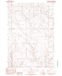
 1982 Red Scaffold1983 Print · USGSThe rural landscape of Ziebach County is documented here in the mid-1970s, within the Cheyenne River Indian Reservation. Researchers can locate ranching landmarks like Red Coat Ranch, the site of White Swan Sch, and a solitary Grave near the creek.
 - 1982 Map of Miller Dam, 1983 Print
 1982 Miller Dam1983 Print · USGSZiebach County and the Cheyenne River Indian Reservation are captured in the early eighties when ranching trails dominated the plains. Researchers can trace the drainage of Cottonwood Creek, locate Miller Dam, and orient themselves by the elevation of Marple Butte.
 - 1982 Map of Longbrake Ranch, 1983 Print
 1982 Longbrake Ranch1983 Print · USGSZiebach County ranching life is documented here during the late twentieth century on the Cheyenne River Indian Reservation. Researchers can locate established family holdings such as Longbrake Ranch and Herren Ranch near the waters of Rattlesnake Creek.
 - 1982 Map of Glad Valley SW, 1983 Print
 1982 Glad Valley SW1983 Print · USGSZiebach County was characterized by wide-open prairie and isolated landmarks like Thunder Butte in the early eighties. Genealogists and historians can trace the intricate drainages of Thunder Butte Creek and Surveyor Creek across the reservation lands.
 - 1982 Map of Glad Valley NW, 1983 Print
 1982 Glad Valley NW1983 Print · USGSZiebach County and the surrounding plains are captured in the early eighties as a intersection of tribal and federal lands. Researchers can trace boundary lines for the Standing Rock Indian Reservation and landmarks like Twin Butte.
 - 1982 Map of Irish Creek SW, 1983 Print
 1982 Irish Creek SW1983 Print · USGSZiebach County land within the Cheyenne River Indian Reservation is captured here during the early eighties. Researchers can trace the drainage of Beaver Trap Creek and locate the remote Dorsey Landing Strip in this prairie landscape.
 - 1982 Map of Diermier Ranch, 1983 Print
 1982 Diermier Ranch1983 Print · USGSThe Ziebach County rangeland in the early eighties is captured here, showing the remote ranching operations of central South Dakota. Researchers can locate family-named homesteads like Diermier Ranch, Johnson Ranch, and Fields Ranch along the winding West Branch Ash Creek.
 - 1982 Map of Irish Creek NW, 1983 Print
 1982 Irish Creek NW1983 Print · USGSThe open plains of Ziebach and Corson counties are captured here in the early eighties, where tribal lands meet at a quiet geographic boundary. Researchers can trace the path of Irish Creek across the Standing Rock Indian Reservation during this era of rural mapping.
 - 1982 Map of Red Elm, 1983 Print
 1982 Red Elm1983 Print · USGSZiebach County in the early eighties shows the quiet settlement of Red Elm as it appeared before modernization. Trace local history through family-named landmarks like Sandoz Dam, the isolated Red Elm Cem, and the path of an abandoned roadway.
 - 1982 Map of Glad Valley SE, 1983 Print
 1982 Glad Valley SE1983 Print · USGSZiebach County in the early eighties is characterized by its wide-open prairie and dramatic landforms within the Cheyenne River Indian Reservation. Researchers can trace the elevation changes at Thunder Butte and the winding paths of West Beaver Trap Creek and Thunder Butte Creek.
 - 1982 Map of Sears Dam, 1983 Print
 1982 Sears Dam1983 Print · USGSThe South Dakota plains within the Cheyenne River Indian Reservation are captured here in the early eighties. Researchers can trace rural family life and land use through labels like Sunnybrook Ch, Mitchell Ranch, and Knight Ranch.
 - 1982 Map of Red Elm SW, 1983 Print
 1982 Red Elm SW1983 Print · USGSThe northern plains along the Cheyenne River Indian Res Bdy are captured here during the early eighties. Researchers can trace the complex drainage of Flint Rock Creek and locate a solitary Water Well amidst changing county lines.
Showing maps 1-25 of 37
Frequently asked questions
- What are the different types of historical maps available for Ziebach County?
- What is the oldest map of Ziebach County?
- Where can I purchase historical maps of Ziebach County for my home or office?
- Where can I download high-res historical maps of Ziebach County?
- Are there historical topographic maps available for Ziebach County?
- Is there historical aerial imagery available for Ziebach County?
- Where are historical maps of Ziebach County sourced from?