
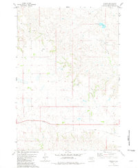
1981 Map of Herbert Creek
USGS Topo · Published 1981About this map
Eagle Butte occupies the northwestern corner of this South Dakota landscape, serving as a primary hub where regional infrastructure meets the open ranch lands of the Cheyenne River Indian Reservation. The settlement pattern is defined by widely dispersed family holdings including the Webb Ranch, Elsey Ranch, and the neighboring W Keckler Ranch and R Keckler Ranch. This 1981 edition, based on earlier 1970s aerial surveys, documents a rural economy tied closely to the water table, evidenced by the prominent Aqueduct line cutting through the center of the quadrangle to support local agriculture and livestock. The terrain is shaped by the drainage systems of Herbert Creek and the East Fork Rudy Creek, while the county line between Dewey Co and Ziebach Co creates a formal boundary across the undulating prairie and draws like Beef Draw. Local community life is anchored at Shupic Park, providing a rare public landmark in this expansive grazing territory.
Find a feature on this map
14 named features on this map. Tap any name to fly to it.
Don’t see what you’re looking for? This feature index may not catch every label — zoom into the map to look around manually.
Map Details
Editions of this 1981 Herbert Creek Map
This is the sole edition of this map. No revisions or reprints were ever made.
Other maps of this area

1953 · McIntosh
USGS Topo · 1:250,000

1954 · Pierre
USGS Topo · 1:250,000

1956 · Herbert Creek SE
USGS Topo · 1:24,000

1958 · Pierre
USGS Topo · 1:250,000

1958 · McIntosh
USGS Topo · 1:250,000

1981 · Herbert Creek NE
USGS Topo · 1:24,000

1981 · Parade SW
USGS Topo · 1:24,000

1981 · Herbert Creek SW
USGS Topo · 1:24,000
1981 · Parade
USGS Topo · 1:24,000

1981 · High Elk Hill SE
USGS Topo · 1:24,000