
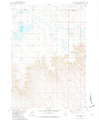
1981 Map of High Elk Hill SE
USGS Topo · Published 1982About this map
Rudy Creek winds through the high plains of Ziebach County, defining a landscape of sparse ranching operations and vast open range. Published in the early 1980s, this survey documents the rural character of the Cheyenne River Indian Reservation, where water sources and family operations are the primary landmarks. The map illustrates a network of unimproved roads and light-duty tracks that connect isolated homesteads like Keller Ranch and Hunt Ranch. While the terrain is dominated by the drainage systems of Dupree Creek and various seasonal draws, evidence of industrial or resource exploration appears in the northern reaches with a specifically marked Well. This topographic record provides a clear view of land use and livestock infrastructure in the South Dakota interior during a period of modern ranching.
Find a feature on this map
5 named features on this map. Tap any name to fly to it.
Don’t see what you’re looking for? This feature index may not catch every label — zoom into the map to look around manually.
Map Details
Editions of this 1981 High Elk Hill SE Map
This is the sole edition of this map. No revisions or reprints were ever made.
Other maps of this area

1954 · Pierre
USGS Topo · 1:250,000

1956 · Cherry Creek NW
USGS Topo · 1:24,000

1956 · Carlin Flat
USGS Topo · 1:24,000

1956 · Alleman Station
USGS Topo · 1:24,000

1958 · Pierre
USGS Topo · 1:250,000

1981 · Herbert Creek
USGS Topo · 1:24,000

1981 · Herbert Creek SW
USGS Topo · 1:24,000

1981 · High Elk Hill NW
USGS Topo · 1:24,000
1981 · High Elk Hill
USGS Topo · 1:24,000

1981 · High Elk Hill SW
USGS Topo · 1:24,000