
1981 Map of Parade SW
USGS Topo · Published 1981About this map
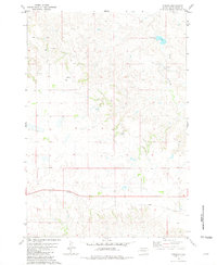
Eagle Butte and North Eagle Butte anchor this prairie landscape as it appeared in the early 1980s. The community infrastructure is well-defined, showing a central Civic Center, a Hosp, and several Radio Towers. Water management in this semi-arid region of Dewey County is evidenced by Brueschke Dam and the intermittent flow of Green Grass Creek, while the local economy and social life are represented by the presence of a Golf Course and Rodeo Grounds. Aviation and utility markings, including the Hunt Landing Strip and various Wells, highlight the practical land use on the Cheyenne River Indian Reservation during this period. The terrain is further defined by survey points like Parade North Base and Parade South Base, providing a detailed view of the high plains topography.
Find a feature on this map
20 named features on this map. Tap any name to fly to it.
Don’t see what you’re looking for? This feature index may not catch every label — zoom into the map to look around manually.
Map Details
Editions of this 1981 Parade SW Map
This is the sole edition of this map. No revisions or reprints were ever made.
Other maps of this area

1952 · Parade NE
USGS Topo · 1:24,000

1952 · Lantry NE
USGS Topo · 1:24,000

1952 · Parade NW
USGS Topo · 1:24,000

1953 · McIntosh
USGS Topo · 1:250,000

1954 · Pierre
USGS Topo · 1:250,000

1958 · Pierre
USGS Topo · 1:250,000

1958 · McIntosh
USGS Topo · 1:250,000

1981 · Herbert Creek
USGS Topo · 1:24,000

1981 · Herbert Creek NE
USGS Topo · 1:24,000
1981 · Parade
USGS Topo · 1:24,000