1940s Maps of Moores Camp, Tennessee
Explore 1 historic maps of Moores Camp from the 1940s. These maps offer a rare glimpse into what life looked like during the 1940s — showing old roads, neighborhoods, homes, and landmarks that have changed or disappeared over time.
Whether you're researching your family's past, planning a metal detecting trip, or studying how Moores Camp's landscape evolved across the 1940s, these high-resolution maps are a powerful tool for exploring the history of this region.
- Focus on a specific era: All maps on this page are from the 1940s, giving you a focused view of this time period.
- See what’s changed: Compare century-old streets, trails, and buildings to today's modern landscape using overlays and satellite layers.
- Research with precision: Use these maps for genealogy, historical research, land use analysis, or educational projects.
- View, download, or print: Maps are fully viewable online in high resolution, and can be downloaded or printed for your own records.
Start exploring Moores Camp's history through authentic maps from the 1940s. This is your window into the past.
Moores Camp, TN maps
(1)- 1946 Map of Fork Mountain, 1947 Print
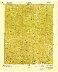 1946 Fork Mountain1947 Print · USGSThe rugged intersections of Scott, Morgan, and Anderson counties are captured here in the mid-1940s, highlighting a remote mountain landscape shaped by the timber and coal industries. Researchers can locate vanished infrastructure like the Lumber Railroad and trace family roots at the Beech Grove Cem and Mooretown.2 unique versions available
End of results
Showing maps 1-1 of 1
Top cities near Moores Camp
- Knoxville historical maps
- Oak Ridge historical maps
- Clinton historical maps
- La Follette historical maps
- Harriman historical maps
- Oliver Springs historical maps
See more
Frequently asked questions
- What are the different types of historical maps available for Moores Camp?
- What is the oldest map of Moores Camp?
- Where can I purchase historical maps of Moores Camp for my home or office?
- Where can I download high-res historical maps of Moores Camp?
- Are there historical topographic maps available for Moores Camp?
- Is there historical aerial imagery available for Moores Camp?
- Where are historical maps of Moores Camp sourced from?