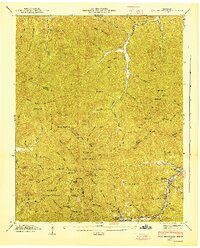
1946 Map of Fork Mountain
USGS Topo · Published 1947About this map
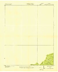
Smoky Mountain and Arch Mountain dominate this mid-century look at the high-elevation Cumberland Plateau, where the boundaries of Scott, Morgan, Anderson, and Campbell counties meet. The landscape reflects a specialized industrial economy centered on logging and coal, evidenced by the Lumber Railroad snaking through the hollows and multiple Incline tracks leading to the New River. Small coal-mining and timber settlements like Mooretown and Fork Mountain are concentrated along the narrow valley floors, connected by the Emory River and Straight Fork Tennessee River. Local genealogy is anchored by the Reeves-Daugherty Cem, Patterson Cem, and Beech Grove Ch., which served families living in the shadows of Bird Mountain and Fork Ridge. Much of the southwestern portion is dedicated to the Morgan State Forest, preserving the wooded character of the Tennessee Valley divide.
Find a feature on this map
87 named features on this map. Tap any name to fly to it.
Don’t see what you’re looking for? This feature index may not catch every label — zoom into the map to look around manually.
Map Details
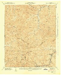
Editions of this 1946 Fork Mountain Map
2 editions found
Other maps of this area

1893 · Briceville
USGS Topo · 1:125,000

1895 · Wartburg
USGS Topo · 1:125,000

1895 · Briceville
USGS Topo · 1:125,000

1896 · Wartburg
USGS Topo · 1:125,000

1896 · Briceville
USGS Topo · 1:125,000

1935 · Gobey
USGS Topo · 1:24,000
1935 · Camp Austin
USGS Topo · 1:24,000

1936 · Hogbell Gap
USGS Topo · 1:24,000
1936 · Block
USGS Topo · 1:24,000
1936 · Duncan Flats
USGS Topo · 1:24,000