1900s (20th Century) Maps of Seeber Flats, Tennessee
Explore 8 historic maps of Seeber Flats from the 1900s (20th Century). These maps offer a rare glimpse into what life looked like during the 1900s — showing old roads, neighborhoods, homes, and landmarks that have changed or disappeared over time.
Whether you're researching your family's past, planning a metal detecting trip, or studying how Seeber Flats's landscape evolved across the 1900s, these high-resolution maps are a powerful tool for exploring the history of this region.
- Focus on a specific era: All maps on this page are from the 1900s, giving you a focused view of this time period.
- See what’s changed: Compare century-old streets, trails, and buildings to today's modern landscape using overlays and satellite layers.
- Research with precision: Use these maps for genealogy, historical research, land use analysis, or educational projects.
- View, download, or print: Maps are fully viewable online in high resolution, and can be downloaded or printed for your own records.
Start exploring Seeber Flats's history through authentic maps from the 1900s. This is your window into the past.
Seeber Flats, TN maps
(8)- 1936 Map of Norris Dam
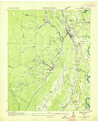
 1936 Norris Dam1936 Print · USGSIn the mid-thirties, the Clinch River valley underwent a total transformation as the new Norris Reservoir reshaped the land. Genealogists can trace family homesteads near Clinton, old burial sites like Leach Cem, and coal towns including Briceville.
 - 1936 Map of Coal Creek
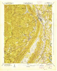
 1936 Coal Creek1936 Print · USGSThe Tennessee coalfields are documented here in the mid-1930s, showing the industrial and social landscape of the Coal Creek valley. Family historians can trace local roots through landmarks like Miners Circle Cem, Briceville, and the Do Better Ch.2 unique versions available
 - 1947 Map of Lake City
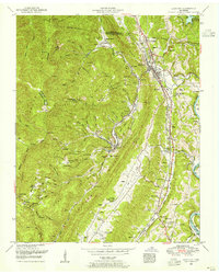
 1947 Lake City1947 Print · USGSPost-war Anderson County comes to life as mining towns and mountain ridges define the landscape. Trace family roots and local history through Briceville, the Miners Circle Cem, and the uniquely named Do Better Ch.
 - 1952 Map of Lake City, 1955 Print
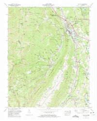
 1952 Lake City1955 Print · USGSAnderson County's coal mining heartland is captured in the early fifties, showing the rail-dependent landscape of Lake City and Briceville. Genealogists can locate family names at Leach Cemetery and Wallace Cemetery, or trace local roots through landmarks like Rush Strong School.2 unique versions available
 - 1956 Map of Corbin, 1966 Print
 1956 Corbin1966 Print · USGSThe Kentucky and Tennessee borderlands are captured here in the mid-fifties, showing the region's shift toward modern interstate travel and reservoir development. Genealogists and historians can trace old community lines near Albany and Monticello or locate early rail junctions along the Southern and Tennessee Central lines.3 unique versions available
 - 1958 Map of Corbin
 1958 Corbin1958 Print · USGSThe Upper Cumberland borderlands appear in the late 1950s as massive reservoirs and early atomic-era growth reshape the region. Trace family roots and vanished landmarks near Lake Cumberland, Oak Ridge, and the Cumberland National Forest.
 - 1973 Map of Lake City, 1975 Print
 1973 Lake City1975 Print · USGSAnderson County during the early 1970s reveals a landscape defined by mountain coal mining and the influence of the TVA. Genealogists can trace family names through dozens of landmarks like Wilson Cem, Byrge Chapel, and the community of Briceville.
 - 1979 Map of Oakridge, 1980 Print
 1979 Oakridge1980 Print · USGSThe eastern Tennessee highlands are captured here in the late 1970s, showcasing a landscape of coal mining and mountain conservation. Genealogists and researchers can locate family landmarks such as Potter Cem, Sunbright Sch, and the historic settlement of Rugby.
End of results
Showing maps 1-8 of 8
Top cities near Seeber Flats
- Knoxville historical maps
- Oak Ridge historical maps
- Powell historical maps
- Clinton historical maps
- La Follette historical maps
- LaFollette historical maps
See more
Frequently asked questions
- What are the different types of historical maps available for Seeber Flats?
- What is the oldest map of Seeber Flats?
- Where can I purchase historical maps of Seeber Flats for my home or office?
- Where can I download high-res historical maps of Seeber Flats?
- Are there historical topographic maps available for Seeber Flats?
- Is there historical aerial imagery available for Seeber Flats?
- Where are historical maps of Seeber Flats sourced from?