1930s Maps of Shelbyville, Tennessee
Explore 4 historic maps of Shelbyville from the 1930s. These maps offer a rare glimpse into what life looked like during the 1930s — showing old roads, neighborhoods, homes, and landmarks that have changed or disappeared over time.
Whether you're researching your family's past, planning a metal detecting trip, or studying how Shelbyville's landscape evolved across the 1930s, these high-resolution maps are a powerful tool for exploring the history of this region.
- Focus on a specific era: All maps on this page are from the 1930s, giving you a focused view of this time period.
- See what’s changed: Compare century-old streets, trails, and buildings to today's modern landscape using overlays and satellite layers.
- Research with precision: Use these maps for genealogy, historical research, land use analysis, or educational projects.
- View, download, or print: Maps are fully viewable online in high resolution, and can be downloaded or printed for your own records.
Start exploring Shelbyville's history through authentic maps from the 1930s. This is your window into the past.
Shelbyville, TN maps
(4)- 1936 Map of Shelbyville
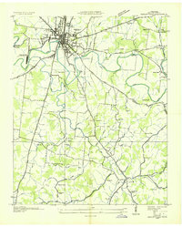 1936 Shelbyville1936 Print · USGSBedford County during the mid-1930s shows a landscape of river-based industry and tightly knit rural settlements along the Duck River. Genealogists and local historians can trace early community life at Shelbyville Mills, Mullins Chapel, and Holly Grove Sch.
 - 1936 Map of Deason
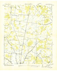 1936 Deason1936 Print · USGSNorthern Bedford County at the peak of the New Deal era reveals a landscape of rural academies and family-named landmarks. Trace ancestral connections at Possumtrot Ch, Harts Chapel, and the historic grounds of Coops Academy.
 - 1936 Map of Unionville
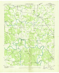 1936 Unionville1936 Print · USGSBedford County's agricultural heartland is documented here in the mid-1930s, where river mills and country schoolhouses define the social geography. Researchers can locate family landmarks like Blackburns Mill, the curiosly named Three Cornered Garden, and the riverside Britton Ford.
 - 1936 Map of Bedford
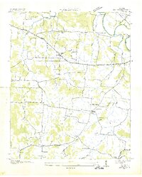 1936 Bedford1936 Print · USGSBedford and the surrounding Tennessee countryside are captured in the mid-1930s just as the Tennessee Valley Authority began its regional surveys. Researchers can locate many vanished family landmarks and community hubs, including Pisgah Cem, New Bethel Ch, and Powell Creek Sch.
End of results
Showing maps 1-4 of 4
Top cities near Shelbyville
- Tullahoma historical maps
- Eagleville historical maps
- Petersburg historical maps
- Wartrace historical maps
- Bell Buckle historical maps
- Normandy historical maps
Top neighborhoods of Shelbyville
Frequently asked questions
- What are the different types of historical maps available for Shelbyville?
- What is the oldest map of Shelbyville?
- Where can I purchase historical maps of Shelbyville for my home or office?
- Where can I download high-res historical maps of Shelbyville?
- Are there historical topographic maps available for Shelbyville?
- Is there historical aerial imagery available for Shelbyville?
- Where are historical maps of Shelbyville sourced from?