1930s Maps of Camden, Tennessee
Explore 5 historic maps of Camden from the 1930s. These maps offer a rare glimpse into what life looked like during the 1930s — showing old roads, neighborhoods, homes, and landmarks that have changed or disappeared over time.
Whether you're researching your family's past, planning a metal detecting trip, or studying how Camden's landscape evolved across the 1930s, these high-resolution maps are a powerful tool for exploring the history of this region.
- Focus on a specific era: All maps on this page are from the 1930s, giving you a focused view of this time period.
- See what’s changed: Compare century-old streets, trails, and buildings to today's modern landscape using overlays and satellite layers.
- Research with precision: Use these maps for genealogy, historical research, land use analysis, or educational projects.
- View, download, or print: Maps are fully viewable online in high resolution, and can be downloaded or printed for your own records.
Start exploring Camden's history through authentic maps from the 1930s. This is your window into the past.
Camden, TN maps
(5)- 1936 Map of Camden
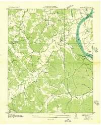
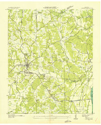 1936 Camden1936 Print · USGSBenton County centers on the town of Camden during the mid-1930s, as the local economy transitioned through New Deal infrastructure projects. Genealogists can trace family roots through numerous rural landmarks like Missionary Grove Ch, Toll Chapel Sch, and the Bethlehem Cem near the river.
 - 1936 Map of Johnsonville
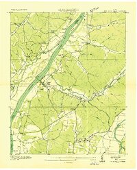 1936 Johnsonville1936 Print · USGSThe Tennessee River corridor in Humphreys County comes alive in the mid-1930s, showing the intersection of rail and river commerce. Genealogists and local historians can trace family sites like Crockett Cem or visit vanished points like Reynoldsburg Landing and Eva Station.
 - 1936 Map of Bruceton
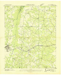 1936 Bruceton1936 Print · USGSBruceton was a bustling rail junction in the 1930s where the Tennessee Central met the St. Louis line. Genealogists can locate family landmarks like Sawyers Mill Zach PO, Cedar Grove Ch, and schools like Garfield Sch.
 - 1936 Map of Harmon Creek
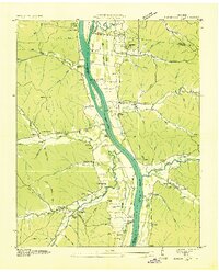 1936 Harmon Creek1936 Print · USGSBenton and Humphreys counties are captured here in the mid-1930s, documenting the riverfront landings and valley farms along the Tennessee River. Genealogists can locate family-named landmarks like the Phifer Place, Carter Cem, and the Harmon Creek Sch.
 - 1936 Map of Rockport
 1936 Rockport1936 Print · USGSBenton County river life is captured here in the mid-1930s, showing a landscape defined by ferry crossings and upland farmsteads. Researchers can trace family sites at Trotters Ferry, Hardin Store, and schools like Tie Hill Sch.
End of results
Showing maps 1-5 of 5
Top cities near Camden
- Waverly historical maps
- New Johnsonville historical maps
- Bruceton historical maps
- Big Sandy historical maps
Top neighborhoods of Camden
Frequently asked questions
- What are the different types of historical maps available for Camden?
- What is the oldest map of Camden?
- Where can I purchase historical maps of Camden for my home or office?
- Where can I download high-res historical maps of Camden?
- Are there historical topographic maps available for Camden?
- Is there historical aerial imagery available for Camden?
- Where are historical maps of Camden sourced from?