1900s (20th Century) Maps of Bruceton, Tennessee
Explore 6 historic maps of Bruceton from the 1900s (20th Century). These maps offer a rare glimpse into what life looked like during the 1900s — showing old roads, neighborhoods, homes, and landmarks that have changed or disappeared over time.
Whether you're researching your family's past, planning a metal detecting trip, or studying how Bruceton's landscape evolved across the 1900s, these high-resolution maps are a powerful tool for exploring the history of this region.
- Focus on a specific era: All maps on this page are from the 1900s, giving you a focused view of this time period.
- See what’s changed: Compare century-old streets, trails, and buildings to today's modern landscape using overlays and satellite layers.
- Research with precision: Use these maps for genealogy, historical research, land use analysis, or educational projects.
- View, download, or print: Maps are fully viewable online in high resolution, and can be downloaded or printed for your own records.
Start exploring Bruceton's history through authentic maps from the 1900s. This is your window into the past.
Bruceton, TN maps
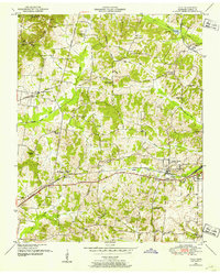
(6)- 1936 Map of Vale
 1936 Vale1936 Print · USGSCarroll County was a landscape of ridge-top schools and vital rail junctions in the mid-1930s. Genealogists and local historians can trace family locations near Hebron Ch, Crews Store, and the busy yards of the Nashville Chattanooga and St Louis railroad.
 - 1936 Map of Bruceton
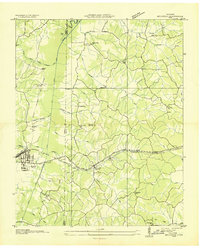 1936 Bruceton1936 Print · USGSBruceton was a bustling rail junction in the 1930s where the Tennessee Central met the St. Louis line. Genealogists can locate family landmarks like Sawyers Mill Zach PO, Cedar Grove Ch, and schools like Garfield Sch.
 - 1950 Map of Bruceton, 1953 Print
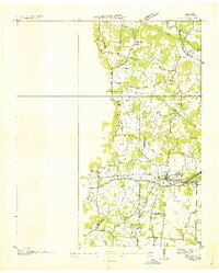
 1950 Bruceton1953 Print · USGSBruceton and the surrounding Tennessee lowlands appear here in the early 1950s, showing a landscape defined by the Nashville Chattanooga and St Louis railway. Local historians can trace old landmarks like Sawyers Mill, Sandy Point Sch, and the historical path of the Natchez Trace.3 unique versions available
 - 1950 Map of Vale, 1953 Print
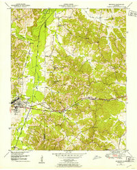
 1950 Vale1953 Print · USGSCarroll County was a hub of rail activity in the early 1950s, centered on the junction at Hollow Rock and Bruceton. Researchers can trace old family sites and schools like Thompson School or visit rural landmarks like Crews Store and the Bethlehem Church.3 unique versions available
 - 1956 Map of Dyersburg, 1960 Print
 1956 Dyersburg1960 Print · USGSThe Four Rivers region comes alive in the mid-fifties, capturing the intricate borderlands of Tennessee, Kentucky, and Missouri. Genealogists and historians can trace the rail-and-river networks connecting Dyersburg, Caruthersville, and the shoreline of Reelfoot Lake.4 unique versions available
 - 1986 Map of McKenzie
 1986 McKenzie1986 Print · USGSWest Tennessee in the mid-eighties was a landscape defined by its deep river forks and the massive waters of Kentucky Lake. Researchers can trace the rail lines of the Louisville & Nashville RR and find local landmarks from Skullbone to the Paris Landing State Park.3 unique versions available
End of results
Showing maps 1-6 of 6
Top cities near Bruceton
- McKenzie historical maps
- Huntingdon historical maps
- Camden historical maps
- Hollow Rock historical maps
- Henry historical maps
- Big Sandy historical maps
See more
Frequently asked questions
- What are the different types of historical maps available for Bruceton?
- What is the oldest map of Bruceton?
- Where can I purchase historical maps of Bruceton for my home or office?
- Where can I download high-res historical maps of Bruceton?
- Are there historical topographic maps available for Bruceton?
- Is there historical aerial imagery available for Bruceton?
- Where are historical maps of Bruceton sourced from?