1930s Maps of New Tazewell, Tennessee
Explore 3 historic maps of New Tazewell from the 1930s. These maps offer a rare glimpse into what life looked like during the 1930s — showing old roads, neighborhoods, homes, and landmarks that have changed or disappeared over time.
Whether you're researching your family's past, planning a metal detecting trip, or studying how New Tazewell's landscape evolved across the 1930s, these high-resolution maps are a powerful tool for exploring the history of this region.
- Focus on a specific era: All maps on this page are from the 1930s, giving you a focused view of this time period.
- See what’s changed: Compare century-old streets, trails, and buildings to today's modern landscape using overlays and satellite layers.
- Research with precision: Use these maps for genealogy, historical research, land use analysis, or educational projects.
- View, download, or print: Maps are fully viewable online in high resolution, and can be downloaded or printed for your own records.
Start exploring New Tazewell's history through authentic maps from the 1930s. This is your window into the past.
New Tazewell, TN maps
(3)- 1936 Map of Clouds
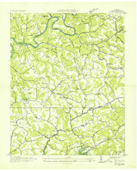 1936 Clouds1936 Print · USGSClaiborne County sits at a crossroads of change in the mid-1930s as the TVA reservoir transforms the Powell River valley. Researchers can trace ancestral footprints through numerous rural landmarks like Kecks Store, the Straight Creek Mines, and Ford Chapel Cem.2 unique versions available
 - 1936 Map of Rutledge
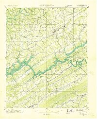 1936 Rutledge1936 Print · USGSClinch River communities faced a major transformation in the mid-1930s as the new reservoir began to fill the valley. You can trace the pre-inundation landscape through landmarks like Beeler Mill, the Straight Creek Mines Sch, and Lone Mountain.
 - 1936 Map of Tazewell
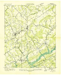 1936 Tazewell1936 Print · USGSClaiborne County appears in the mid-1930s just as the Tennessee Valley Authority began filling the Norris Reservoir. Genealogists and researchers can locate numerous family-named landmarks like Oak Cem, the Greer Tunnel, and rural centers such as Memorial Consolidated Sch.
End of results
Showing maps 1-3 of 3
Top cities near New Tazewell
- Morristown historical maps
- Middlesboro historical maps
- Harrogate historical maps
- Maynardville historical maps
- Tazewell historical maps
- Rutledge historical maps
See more
Top neighborhoods of New Tazewell
Frequently asked questions
- What are the different types of historical maps available for New Tazewell?
- What is the oldest map of New Tazewell?
- Where can I purchase historical maps of New Tazewell for my home or office?
- Where can I download high-res historical maps of New Tazewell?
- Are there historical topographic maps available for New Tazewell?
- Is there historical aerial imagery available for New Tazewell?
- Where are historical maps of New Tazewell sourced from?