1970s Maps of Coffee County, Tennessee
Explore 8 historic maps of Coffee County from the 1970s. These maps offer a rare glimpse into what life looked like during the 1970s — showing old roads, neighborhoods, homes, and landmarks that have changed or disappeared over time.
Whether you're researching your family's past, planning a metal detecting trip, or studying how Coffee County's landscape evolved across the 1970s, these high-resolution maps are a powerful tool for exploring the history of this region.
- Focus on a specific era: All maps on this page are from the 1970s, giving you a focused view of this time period.
- See what’s changed: Compare century-old streets, trails, and buildings to today's modern landscape using overlays and satellite layers.
- Research with precision: Use these maps for genealogy, historical research, land use analysis, or educational projects.
- View, download, or print: Maps are fully viewable online in high resolution, and can be downloaded or printed for your own records.
Start exploring Coffee County's history through authentic maps from the 1970s. This is your window into the past.
Coffee County, TN maps
(8)- 1972 Map of Ovoca, 1973 Print
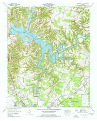
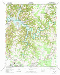 1972 Ovoca1973 Print · USGSTullahoma and the Duck River valley are captured here in the early seventies during the construction of the Normandy Dam. Genealogists and local historians can trace rural family sites like Hickerson Cemetery and the Fourth Model Community Center alongside the growing Tullahoma city limits.2 unique versions available
 - 1972 Map of Tullahoma, 1973 Print
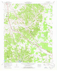
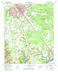 1972 Tullahoma1973 Print · USGSTullahoma and Estill Springs are captured here during the early seventies as the region balanced its railroad heritage with the growing aerospace presence of the Arnold Engineering Development Center. Local historians can trace the rising waters of Tims Ford Lake and locate old family burial sites like Gault Cem and Lasater Cem.5 unique versions available
 - 1972 Map of Capitol Hill, 1973 Print
 1972 Capitol Hill1973 Print · USGSFranklin and Coffee counties during the early 1970s reveal a unique mix of small-town life and high-tech research centers. Genealogists and local historians can locate family cemeteries like Beth Page Cem alongside the University of Tennessee Space Institute and the sprawling Woods Reservoir.4 unique versions available
 - 1972 Map of Manchester, 1974 Print
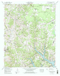
 1972 Manchester1974 Print · USGSManchester and its surrounding Coffee County highlands are captured in the early seventies, just before the landscape changed with the damming of the river. Researchers can trace family sites like Granny Hickerson Cem, explore the prehistoric Old Stone Fort State Park, or locate the extensive Arnold Engineering Development Center.4 unique versions available
 - 1976 Map of Normandy Lake, 1977 Print
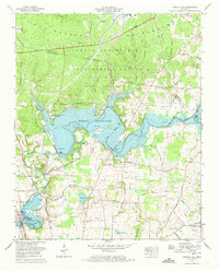
 1976 Normandy Lake1977 Print · USGSIn the mid-1970s, the newly formed Normandy Lake reshaped the Coffee County landscape near Tullahoma. Genealogists and local historians can trace family cemeteries like Huffman Cem and Blanton Cem alongside historic routes like the Old Stage Road.4 unique versions available
 - 1976 Map of Noah, 1978 Print
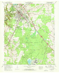
 1976 Noah1978 Print · USGSCoffee County and the Bedford County line are captured in the late seventies, showing a landscape defined by small farming communities and family homesteads. Researchers can trace ancestral locations through several family-named landmarks like McMichael Cem, Huffman Spring, and the Noah Fork Ch.
 - 1978 Map of Lynchburg East
 1978 Lynchburg East1978 Print · USGSMoore County in the late seventies is captured here at the intersection of rural heritage and modern development. Researchers can trace numerous family cemeteries such as Sawyer Cem and Bobo Cem or explore the early footprint of Motlow State Community College.
 - 1979 Map of Chattanooga, 1980 Print
 1979 Chattanooga1980 Print · USGSSoutheast Tennessee in the late seventies reveals a landscape shaped by massive TVA river projects and the industrial strength of the Cumberland Plateau. Genealogists and historians can trace the rail-to-river network through L & N RR junctions, the University of the South, and the Volunteer Army Ammunition Plant.
End of results
Showing maps 1-8 of 8
Top cities of Coffee County
Frequently asked questions
- What are the different types of historical maps available for Coffee County?
- What is the oldest map of Coffee County?
- Where can I purchase historical maps of Coffee County for my home or office?
- Where can I download high-res historical maps of Coffee County?
- Are there historical topographic maps available for Coffee County?
- Is there historical aerial imagery available for Coffee County?
- Where are historical maps of Coffee County sourced from?