1900s (20th Century) Maps of Ovoca, Tennessee
Explore 8 historic maps of Ovoca from the 1900s (20th Century). These maps offer a rare glimpse into what life looked like during the 1900s — showing old roads, neighborhoods, homes, and landmarks that have changed or disappeared over time.
Whether you're researching your family's past, planning a metal detecting trip, or studying how Ovoca's landscape evolved across the 1900s, these high-resolution maps are a powerful tool for exploring the history of this region.
- Focus on a specific era: All maps on this page are from the 1900s, giving you a focused view of this time period.
- See what’s changed: Compare century-old streets, trails, and buildings to today's modern landscape using overlays and satellite layers.
- Research with precision: Use these maps for genealogy, historical research, land use analysis, or educational projects.
- View, download, or print: Maps are fully viewable online in high resolution, and can be downloaded or printed for your own records.
Start exploring Ovoca's history through authentic maps from the 1900s. This is your window into the past.
Ovoca, TN maps
(8)- 1936 Map of Ovoca
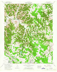
 1936 Ovoca1936 Print · USGSCoffee County's rural landscape is captured here in the mid-1930s as the Tennessee Valley Authority mapped the region's complex river systems. Genealogists can locate family landmarks such as the Ovoca Orphans Home, the Holland Hill Cem, and numerous Duck River crossings like Richardson Ford.
 - 1941 Map of Ovoca, 1943 Print
 1941 Ovoca1943 Print · USGSCoffee County in the early 1940s reflects a rural landscape undergoing rapid change as the military expanded its footprint. Genealogists can locate family-named crossings like Richardson Ford and local landmarks such as the Ovoca Orphans Home or Hickerson Station.2 unique versions available
 - 1943 Map of Mc Minnville, 1944 Print
 1943 Mc Minnville1944 Print · USGSMid-Tennessee is captured here during the mobilization of the early 1940s, showing the vast Camp Forrest Military Reservation and thriving rail towns. Trace the N C & ST L line through Mcminnville or locate smaller rural hubs like Morrison and Hickerson Station.
 - 1956 Map of Columbia, 1960 Print
 1956 Columbia1960 Print · USGSMiddle Tennessee in the mid-fifties presents a landscape of established river towns and critical rail hubs before the arrival of the modern interstate system. Researchers can trace the routes of the Louisville and Nashville railroad or locate historic landmarks like Stones River National Military Park and the Tennessee National Wildlife Refuge.6 unique versions available
 - 1962 Map of Ovoca, 1965 Print
 1962 Ovoca1965 Print · USGSCoffee County underwent significant changes in the 1960s as aerospace engineering met traditional Tennessee hill country. Researchers can trace the development of Tullahoma and the Arnold Engineering Development Center alongside old landmarks like Blanton Chapel and Hickerson Station.
 - 1972 Map of Ovoca, 1973 Print
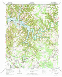 1972 Ovoca1973 Print · USGSTullahoma and the Duck River valley are captured here in the early seventies during the construction of the Normandy Dam. Genealogists and local historians can trace rural family sites like Hickerson Cemetery and the Fourth Model Community Center alongside the growing Tullahoma city limits.2 unique versions available
 - 1976 Map of Normandy Lake, 1977 Print
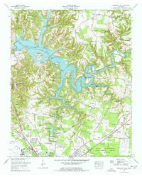 1976 Normandy Lake1977 Print · USGSIn the mid-1970s, the newly formed Normandy Lake reshaped the Coffee County landscape near Tullahoma. Genealogists and local historians can trace family cemeteries like Huffman Cem and Blanton Cem alongside historic routes like the Old Stage Road.4 unique versions available
 - 1981 Map of Tullahoma, 1982 Print
 1981 Tullahoma1982 Print · USGSSouthern Tennessee enters the 1980s with a mix of aerospace technology and deep rural roots. Researchers can trace the L & N RR through Shelbyville and Fayetteville or locate family sites like Old Salem Cem and Blanton Chapel near the Cumberland Plateau.
End of results
Showing maps 1-8 of 8
Top cities near Ovoca
- Shelbyville historical maps
- Tullahoma historical maps
- Manchester historical maps
- Winchester historical maps
- Estill Springs historical maps
- Decherd historical maps
See more
Frequently asked questions
- What are the different types of historical maps available for Ovoca?
- What is the oldest map of Ovoca?
- Where can I purchase historical maps of Ovoca for my home or office?
- Where can I download high-res historical maps of Ovoca?
- Are there historical topographic maps available for Ovoca?
- Is there historical aerial imagery available for Ovoca?
- Where are historical maps of Ovoca sourced from?