1940s Maps of Mount Zion, Tennessee
Explore 2 historic maps of Mount Zion from the 1940s. These maps offer a rare glimpse into what life looked like during the 1940s — showing old roads, neighborhoods, homes, and landmarks that have changed or disappeared over time.
Whether you're researching your family's past, planning a metal detecting trip, or studying how Mount Zion's landscape evolved across the 1940s, these high-resolution maps are a powerful tool for exploring the history of this region.
- Focus on a specific era: All maps on this page are from the 1940s, giving you a focused view of this time period.
- See what’s changed: Compare century-old streets, trails, and buildings to today's modern landscape using overlays and satellite layers.
- Research with precision: Use these maps for genealogy, historical research, land use analysis, or educational projects.
- View, download, or print: Maps are fully viewable online in high resolution, and can be downloaded or printed for your own records.
Start exploring Mount Zion's history through authentic maps from the 1940s. This is your window into the past.
Mount Zion, TN maps
(2)- 1946 Map of Roddy, 1960 Print
 1946 Roddy1960 Print · USGSThe Cumberland Plateau meets the Tennessee Valley just after the war, where rail lines and ridgeline gaps defined local travel. Researchers can trace family sites like Williams Cem or follow the old tracks of the Tennessee Central Railroad near Roddy.2 unique versions available
 - 1947 Map of Roddy, 1948 Print
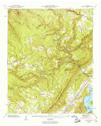
 1947 Roddy1948 Print · USGSThe Cumberland Escarpment and Watts Bar Reservoir define this 1940s landscape on the borders of Rhea and Roane counties. Genealogists can trace family names at Williams Cem, locate the Big Sandy Sch, and find the old Gibson Inn.
End of results
Showing maps 1-2 of 2
Top cities near Mount Zion
- Crossville historical maps
- Fairfield Glade historical maps
- Harriman historical maps
- Rockwood historical maps
- Spring City historical maps
- Crab Orchard historical maps
Frequently asked questions
- What are the different types of historical maps available for Mount Zion?
- What is the oldest map of Mount Zion?
- Where can I purchase historical maps of Mount Zion for my home or office?
- Where can I download high-res historical maps of Mount Zion?
- Are there historical topographic maps available for Mount Zion?
- Is there historical aerial imagery available for Mount Zion?
- Where are historical maps of Mount Zion sourced from?