
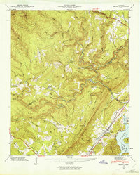
1946 Map of Roddy
USGS Topo · Published 1960About this map
The Cumberland Escarpment dominates this 1946 landscape, marking a sharp geological transition where the high plateau falls away toward the Whites Creek Valley. Along the base of this ridge, the Southern Railway corridor serves the community of Roddy, while the northern portion of the quadrangle is traversed by the Tennessee Central Railroad through the area of America. This era shows a rural landscape defined by narrow ridges like Gibson Ridge and Wolfpit Ridge, where life centered around small institutions like Dogwood Ch and the Big Sandy Sch.
Find a feature on this map
103 named features on this map. Tap any name to fly to it.
Don’t see what you’re looking for? This feature index may not catch every label — zoom into the map to look around manually.
Map Details
Editions of this 1946 Roddy Map
2 editions found
Other maps of this area

1887 · Kingston
USGS Topo · 1:125,000

1891 · Kingston
USGS Topo · 1:125,000

1893 · Kingston
USGS Topo · 1:125,000

1935 · Rockwood
USGS Topo · 1:24,000

1935 · Pennine
USGS Topo · 1:24,000

1936 · Roddy
USGS Topo · 1:24,000
1936 · Ozone
USGS Topo · 1:24,000

1936 · Cardiff
USGS Topo · 1:24,000

1936 · Spring City
USGS Topo · 1:24,000
1936 · Grassy Cove
USGS Topo · 1:24,000