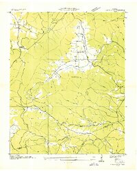
1936 Map of Grassy Cove
USGS Topo · Published 1936About this map
Grassy Cove dominates this 1936 survey, appearing as a distinct limestone karst landscape where the drainage of Grassy Cove Creek disappears into the subterranean reaches of Cumberland Mountain. This depression in the Cumberland Plateau created a unique agricultural pocket served by the State Highway No 68, with the central settlement featuring a Cem and local residences. To the south and west, the terrain rises sharply toward Hinch Mtn and Dorton Knob, marking the boundary between Cumberland and Bledsoe counties. Smaller communities and rural landmarks such as Linary in the northwest and Happy Top near the southern border reflect the dispersed nature of mountain life during the mid-1930s. Notable institutions like the Jewett Ch, Linary Sch, and Alloway Sch are precisely located, providing essential data for genealogists tracing family roots in this corner of the plateau.
Find a feature on this map
46 named features on this map. Tap any name to fly to it.
Don’t see what you’re looking for? This feature index may not catch every label — zoom into the map to look around manually.
Map Details
Editions of this 1936 Grassy Cove Map
This is the sole edition of this map. No revisions or reprints were ever made.
Other maps of this area

1887 · Kingston
USGS Topo · 1:125,000

1891 · Kingston
USGS Topo · 1:125,000

1892 · Pikeville
USGS Topo · 1:125,000

1893 · Kingston
USGS Topo · 1:125,000

1895 · Pikeville
USGS Topo · 1:125,000

1909 · Sequatchie Valley
USGS Topo · 1:62,500

1910 · Pikeville
USGS Topo · 1:62,500

1912 · Crossville
USGS Topo · 1:62,500

1935 · Melvine
USGS Topo · 1:24,000

1935 · Pennine
USGS Topo · 1:24,000