
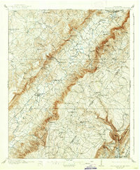
1910 Map of Pikeville
USGS Topo · Published 1910About this map
The Sequatchie River valley serves as the central artery for this 1910 survey, defining the agricultural and industrial layout of Bledsoe County. The town of Pikeville acts as the primary hub, situated where the Nashville Chattanooga and St Louis RR terminates near the river banks. This rail connection facilitated the movement of goods from the numerous mills dotting the landscape, such as Mansfield Mill, Hembree Mill, and Henderson Mill. Away from the valley floor, the terrain is marked by a series of named gaps and knobs like Browns Gap and Worthington Knob, which dictated early transportation routes.
Find a feature on this map
95 named features on this map. Tap any name to fly to it.
Don’t see what you’re looking for? This feature index may not catch every label — zoom into the map to look around manually.
Map Details
Editions of this 1910 Pikeville Map
2 editions found
Other maps of this area

1886 · Cleveland
USGS Topo · 1:125,000

1887 · Kingston
USGS Topo · 1:125,000

1888 · Chattanooga
USGS Topo · 1:125,000

1891 · Kingston
USGS Topo · 1:125,000

1892 · Pikeville
USGS Topo · 1:125,000

1892 · Cleveland
USGS Topo · 1:125,000

1893 · Chattanooga
USGS Topo · 1:125,000

1893 · Kingston
USGS Topo · 1:125,000

1895 · Cleveland
USGS Topo · 1:125,000

1895 · Pikeville
USGS Topo · 1:125,000